IMAGES TAKEN NEAR TO
Wellington Road, BOURNEMOUTH, BH8 8FU
Introduction
This page details the photographs taken nearby to Wellington Road, BH8 8FU by members of the Geograph project.
The Geograph project started in 2005 with the aim of publishing, organising and preserving representative images for every square kilometre of Great Britain, Ireland and the Isle of Man.

There are currently over 7.5m images from over14,400 individuals and you can help contribute to the project by visiting https://www.geograph.org.uk
Image Map
Images are licensed for reuse under creativecommons.org/licenses/by-sa/2.0
Notes
- Clicking on the map will re-center to the selected point.
- The higher the marker number, the further away the image location is from the centre of the postcode.
Image Listing (289 Images Found)
Images are licensed for reuse under creativecommons.org/licenses/by-sa/2.0
Image
Details
Distance
1
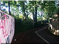
Springbourne: footpath C13 from Wellington Road
This public footpath runs along the south side of the A338 Wessex Way, and leads to Portchester Place and the footbridge across the main road. Another path does similar on the northern side (see Image).
See Image for the next picture along the path, and links to further photos.
Image: © Chris Downer
Taken: 3 Jul 2016
0.01 miles
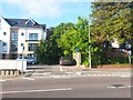
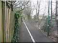
2
Springbourne: footpath C13 emerges onto Wellington Road
The opposing view to Image] (minus the dodgily parked car). See Image for the next view along the path behind us.
Image: © Chris Downer
Taken: 3 Jul 2016
0.01 miles
3
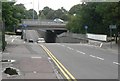
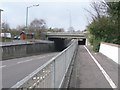
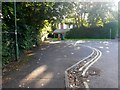
Bournemouth: Wellington Road underpass
When the Image was put in in the 1970s, rather than elevate the new road further, Wellington Road was lowered to accommodate the bridge. The pavements also dip, but not nearly as much. The adverse camber of the main road above can be discerned from here.
Image: © Chris Downer
Taken: 10 Jul 2008
0.01 miles
4
Bournemouth: Wellington Road underpass
When the main A338 Wessex Way was built in the 1970s, only Wellington Road was retained as a crossing point for vehicles; the parallel roads to the north have been severed. Here we see where the carriageway of Wellington Road has been lowered to allow the dual carriageway to pass over without the need for a high viaduct.
The camber of the main road can also be discerned from this point – with the far carriageway virtually visible beyond the nearer one, despite the fact that we are clearly below that level.
Image: © Chris Downer
Taken: 26 Mar 2009
0.01 miles
5
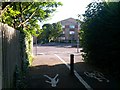
Springbourne: footpath C13 turns to abut the Wessex Way
This public footpath from Wellington Road reaches the edge of the main Wessex Way, and turns a corner to run alongside it to Portchester Place and the footbridge. The Wessex Way is the whole reason that this path exists; before it, the roads such as Portchester Place, were through roads to the other side of the main road.
See Image for the next picture along the path ahead (and more discussion on the side-roads before the Wessex Way) and Image for a view of the path behind us.
Image: © Chris Downer
Taken: 3 Jul 2016
0.02 miles
6
Springbourne: foot/cycle path alongside Wessex Way
The main A338 Wessex Way was built in the mid 1970s and involved the severing of the parallel roads, running east-west, which crossed its path. The resulting dead-ends are connected by a footpath, which has more recently become a joint cycleway, running along each side of the main road.
Image: © Chris Downer
Taken: 26 Mar 2009
0.03 miles
7
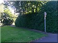
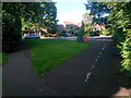
Malmesbury Park: footpath C20 from its northern end
The opposing view to Image] along this short public footpath whose purpose is to cut the corner for those wishing to turn right from Portchester Road (foreground) onto path C18 in the direction of Wellington Road.
The No Cycling sign refers only to this path; path C18 ahead is marked out as a shared route.
Image: © Chris Downer
Taken: 3 Jul 2016
0.04 miles
8
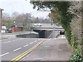
Bournemouth: looking through Wellington Road underpass
A closer view of Image We can see here that the pavements, which are much higher than the roadway, do not dip at the centre of the underpass but considerably this side.
Image: © Chris Downer
Taken: 26 Mar 2009
0.04 miles
9
Malmesbury Park: footpath C18 crosses the Portchester Road dead end
This public footpath, alongside the main A338 Wessex Way which is behind the trees to our left, leads from Ascham Road behind us to Wellington Road ahead, and does so via the dead end of Portchester Road, which we see here.
Before the Wessex Way, Portchester Road was a through route to what is now Portchester Place on the other side.
See Image] for the view of the path arriving here from behind us, and Image for the view towards us from far-left.
Image: © Chris Downer
Taken: 3 Jul 2016
0.04 miles
10
Malmesbury Park: footpath C18 (and C20) arrives on Portchester Road
Looking along this public footpath, alongside the A338 Wessex Way which is to our right, as it reaches the Portchester Road dead end before continuing to the similar dead end of Ascham Road.
Also, to our left, public footpath C20 cuts off the corner for those wishing to turn sharp left here.
See:
Image] for the view towards us on footpath C18 (right);
Image for the view towards us on footpath C20 (left); and
Image for the next view along the path behind us towards Wellington Road.
Image: © Chris Downer
Taken: 3 Jul 2016
0.04 miles