IMAGES TAKEN NEAR TO
Prince Of Wales Road, BOURNEMOUTH, BH4 9HB
Introduction
This page details the photographs taken nearby to Prince Of Wales Road, BH4 9HB by members of the Geograph project.
The Geograph project started in 2005 with the aim of publishing, organising and preserving representative images for every square kilometre of Great Britain, Ireland and the Isle of Man.

There are currently over 7.5m images from over14,400 individuals and you can help contribute to the project by visiting https://www.geograph.org.uk
Image Map
Images are licensed for reuse under creativecommons.org/licenses/by-sa/2.0
Notes
- Clicking on the map will re-center to the selected point.
- The higher the marker number, the further away the image location is from the centre of the postcode.
Image Listing (154 Images Found)
Images are licensed for reuse under creativecommons.org/licenses/by-sa/2.0
Image
Details
Distance
1
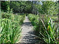
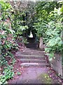
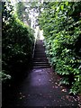
Westbourne: footpath A10 to Snowdon Road
Although nowhere near as mountainous as the namesake of the destination road, this is a pretty steep path which ascends from Prince of Wales Road. It comprises steps throughout its length.
See Image for a downward view midway along the path.
Image: © Chris Downer
Taken: 29 Jun 2016
0.01 miles
2
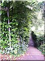
Westbourne: footpath A10 descends to Prince of Wales Road
Looking down the lower half of this steep public footpath from Snowdon Road.
See Image] for the view up the path from the bottom, and Image for a view behind us.
Image: © Chris Downer
Taken: 29 Jun 2016
0.02 miles
3
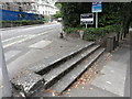
inlaid step feature on Surrey Road
Old concrete steps within the tarmac surface on Surrey Road with the junction of Prince of Wales Road.
Image: © Mat Tuck
Taken: 23 Jul 2013
0.02 miles
4
Westbourne: skew-whiff steps on footpath A10
Looking up this steep public footpath towards the Snowdon Road end. The tree on the left has caused the surface to lift somewhat here, ruining the geometric appearance of the path.
See Image] for the view behind us and Image for a view from the top end of the path.
Image: © Chris Downer
Taken: 29 Jun 2016
0.03 miles
5
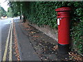
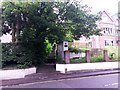
Westbourne: postbox № BH4 47, Surrey Road
The Westbourne and western Bournemouth area has several Victorian postboxes such as this one in Surrey Road. Just beyond is a very acute crossroads with Prince of Wales Road, which sensibly was made a staggered junction many years ago.
Image: © Chris Downer
Taken: 4 Sep 2008
0.03 miles
6
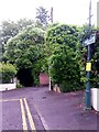
Westbourne: footpath A10 from Snowdon Road
Looking across the dead end of Snowdon Road, from where a steep public footpath, signposted on the lamppost, descends to Prince of Wales Road.
See Image for the next view along the path, including text links to further pictures.
Image: © Chris Downer
Taken: 29 Jun 2016
0.03 miles
7
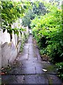
Westbourne: footpath A09 to the Upper Gardens
One of two public footpaths leading from this stretch of Surrey Road to the Upper Gardens. Unlike the other one (Image), this one is steps first and then flat.
See Image for a view up the steps towards us.
Image: © Chris Downer
Taken: 29 Jun 2016
0.06 miles
8
Westbourne: up the steps on footpath A09
The opposite view to Image] - the combination of thickly overhanging hedges and dreary dampness after a day of rain makes for a rather dark view.
The words NO CYCLING are helpfully painted on the tarmac facing those who have descended the steps.
The path leads behind us to the Upper Gardens - see Image] for a view along the path from that end.
Image: © Chris Downer
Taken: 29 Jun 2016
0.06 miles
9
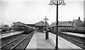
Bournemouth West Station
View eastward, to buffer-stops; terminus of ex-LSWR main line from London and Southampton via Bournemouth Central, also of lines from Poole, Broadstone, Wimborne etc. including the Somerset & Dorset Joint (S&DJ) line from Bath via Templecombe. The station was closed completely on 4/10/65 and all remaining services diverted to Bournemouth Central.
Image: © Ben Brooksbank
Taken: 20 Apr 1963
0.06 miles