IMAGES TAKEN NEAR TO
School Lane, SWANAGE, BH19 3AJ
Introduction
This page details the photographs taken nearby to School Lane, BH19 3AJ by members of the Geograph project.
The Geograph project started in 2005 with the aim of publishing, organising and preserving representative images for every square kilometre of Great Britain, Ireland and the Isle of Man.

There are currently over 7.5m images from over14,400 individuals and you can help contribute to the project by visiting https://www.geograph.org.uk
Image Map (Loading...)


Getting Data...Please wait
Leaflet Map data © OpenStreetMap
Images are licensed for reuse under creativecommons.org/licenses/by-sa/2.0
Notes
- Clicking on the map will re-center to the selected point.
- The higher the marker number, the further away the image location is from the centre of the postcode.
Image Listing (242 Images Found)
Images are licensed for reuse under creativecommons.org/licenses/by-sa/2.0
Image
Details
Distance
1
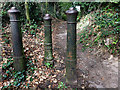
A trio of posts on a footpath near Studland church
Perhaps an import from London like many of the bollards at Durlston Castle near Swanage?
Image: © Phil Champion
Taken: 4 Sep 2019
0.03 miles
2
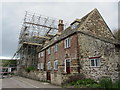
Manor Farm House and Manor Farm Cottage, Studland
There is extensive work being carried out on this National Trust owned property. It has been listed since 1959.The original parts of the building date from the 18th century, with later additions in about 1870. It is easy to see the mix of rubble stone and brick construction. Even the front boundary wall is listed, being of stone construction with battlements.
Image: © Carol Walker
Taken: 30 May 2014
0.05 miles
3
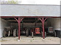
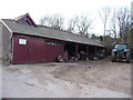
A collection of tractors
These tractors are in a barn at the side of the Manor Farm Tea Rooms.
Image: © Carol Walker
Taken: 30 May 2014
0.05 miles
4
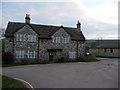
Studland : Manor Farmhouse
Manor Farmhouse on Watery Lane is a farm mainly producing milk and dairy products.
Image: © Lewis Clarke
Taken: 12 Feb 2010
0.05 miles
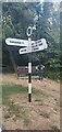
5
Studland : Signpost & Manor Farmhouse
A signpost with directions to the church and Swanage and behind it on Watery Lane, the farmhouse.
Image: © Lewis Clarke
Taken: 12 Feb 2010
0.05 miles
6
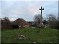
Studland : Ancient Saxon Cross Location
This isn't the ancient Saxon cross, but it was placed here in 1978 on the site of an ancient Saxon cross.
Image: © Lewis Clarke
Taken: 12 Feb 2010
0.06 miles
7
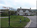
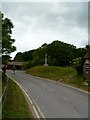
Direction Sign ? Signpost on Church Road in Studland
Located on the east side of the junction of Church Road and School Lane, in Studland parish. 4 arms and annulus finial. See also https://www.geograph.org.uk/photo/6293306.
Milestone Society National ID: DO_SZ0382
Image: © D Dougherty
Taken: 24 Jul 2022
0.06 miles
8
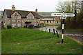
Junction, Studland
A slightly staggered crossroads, with Manor Farm in the background - the cross http://www.waymarking.com/waymarks/WM54CA_Studland_Cross_Studland_Isle_of_Purbeck_Dorset shown in http://www.geograph.org.uk/search.php?i=102850309 can be seen in front of the left gable.
Image: © Derek Harper
Taken: 5 Apr 2019
0.06 miles
9
Studland, Spaceship Earth
Cross on a green near Image The faces show different aspects of human, animal and botanical activity, with Christian symbolism and pre-Norman decoration. http://www.waymarking.com/waymarks/WM54CA_Studland_Cross_Studland_Isle_of_Purbeck_Dorset
Image: © Mike Faherty
Taken: 27 May 2011
0.06 miles
10
Studland : Manor Farm
A sign on this barn door says that Manor Farm produces top quality farm assured milk.
Image: © Lewis Clarke
Taken: 12 Feb 2010
0.06 miles