IMAGES TAKEN NEAR TO
Jenni Close, BOURNEMOUTH, BH11 9BA
Introduction
This page details the photographs taken nearby to Jenni Close, BH11 9BA by members of the Geograph project.
The Geograph project started in 2005 with the aim of publishing, organising and preserving representative images for every square kilometre of Great Britain, Ireland and the Isle of Man.

There are currently over 7.5m images from over14,400 individuals and you can help contribute to the project by visiting https://www.geograph.org.uk
Image Map (Loading...)


Getting Data...Please wait
Leaflet Map data © OpenStreetMap
Images are licensed for reuse under creativecommons.org/licenses/by-sa/2.0
Notes
- Clicking on the map will re-center to the selected point.
- The higher the marker number, the further away the image location is from the centre of the postcode.
Image Listing (98 Images Found)
Images are licensed for reuse under creativecommons.org/licenses/by-sa/2.0
Image
Details
Distance
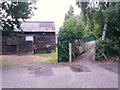
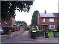
1
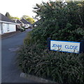
Bear Cross: Jenni Close
A small, modern development of bungalows behind back gardens of the main Wimborne Road. There are curiously many of these little infill developments in the area named after girls' names - Emma Close and Samantha Close are two that spring immediately to mind. This one has a very specific spelling rather than Jenny or Jennifer, so maybe they are named after daughters or wives of developers!
The sign is a modern one, from 2010-15 but it is plain rather than featuring the usual council logo, perhaps signifying that it is a private road, unadopted by the council.
This is photo no.214 of a series of 453 in my coronavirus lockdown walking project:
See https://www.geograph.org.uk/article/My-2020-Coronavirus-Lockdown-walking-project for the complete set of photos.
Image: © Chris Downer
Taken: 16 Apr 2020
0.02 miles
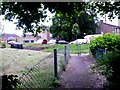
2

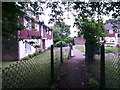
Kinson: passing 2 Anstey Close on footpath E21
This public footpath leads from Baker Road, behind us, to Wimborne Road and on the way passes the dead end of Anstey Close, just ahead. The block of flats on the right is number 2 Anstey Close.
See Image for the view towards us from the end of this stretch of the path, and Image for the next view behind us. Each has links to further photos on the route.
Image: © Chris Downer
Taken: 18 Mar 2017
0.03 miles
3
Kinson: footpath E21 heads for Baker Road
The footpath from Wimborne Road (behind us) crosses the dead end of Anstey Close, here, and continues between two chain-link fences to Baker Road.
Anstey Close comprises four blocks of flats - it is number 2 that we see on our left.
See Image for a view behind us from just into the path ahead, and Image for the next view on the path ahead - each with links to further photos on the route.
Image: © Chris Downer
Taken: 30 Jun 2016
0.03 miles
4
Kinson: 3 Anstey Close and footpath E21
Looking along the public footpath from Wimborne Road (ahead) to Baker Road (behind) as it passes the dead end of Anstey Close. The close comprises four blocks of flats, 1 and 2 to our right, 3 pictured here, and 4 partially in shot in the background.
See Image for a view towards us from just past the end of the fences, and Image] for a view into Anstey Close from the path as it passes the bushes far left.
Image: © Chris Downer
Taken: 30 Jun 2016
0.03 miles
5
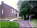
Kinson: footpath E21 passes the Scout hut
Looking along this public footpath as it heads for Baker Road, passing the Scout hut as it does so.
See Image for the next picture along the path ahead, and Image] for the next picture behind us.
Image: © Chris Downer
Taken: 30 Jun 2016
0.03 miles
6
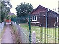
Kinson: Scout hut and footpath E21 to Anstey Close
This public footpath uses the driveway of the Scout hut up to this point, and then bears right between two chain-link fences to Anstey Road and, eventually, Wimborne Road.
See Image] for the next picture along the path ahead, and Image for the view from the end of the drive behind us.
Image: © Chris Downer
Taken: 30 Jun 2016
0.03 miles
7
Kinson: footpath E21 heads north from Anstey Close
Looking across the dead end of Anstey Close, the halfway point on this public footpath from Wimborne Road to Baker Road. Ahead of us, we see the stretch towards Wimborne Road, while the path continues along the house frontages off the left-hand edge of the picture to Baker Road.
See Image for a view along the frontage part of the path, from off to the left, and Image for the view towards us from the path ahead. Each has links to further photos along the route.
Image: © Chris Downer
Taken: 18 Mar 2017
0.04 miles
8
Kinson: footpath E21 reaches Anstey Close from Wimborne Road
Looking along this public footpath as it arrives at the dead end of Anstey Close, whereupon it bears right and continues to Baker Road.
See Image for the next view on the path behind us, and Image for the view towards us from the road ahead - each with links to further photos on the path.
Image: © Chris Downer
Taken: 30 Jun 2016
0.04 miles
9
Kinson: northern segment of footpath E21
This public footpath approaches Wimborne Road, ahead, from Baker Road via Anstey Close.
See Image for the emergence of the path onto the road ahead, and Image for the view behind us, with links to further photos on the route.
Image: © Chris Downer
Taken: 18 Mar 2017
0.04 miles
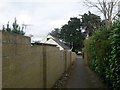
10
Kinson: footpath E21 to Anstey Close and Wimborne Road
Looking across Baker Road, along the driveway to the Scout hut which forms the start of a public footpath to Wimborne Road via Anstey Close.
See Image] for the view towards us from midway along the driveway, with links to further photos along the route.
Image: © Chris Downer
Taken: 30 Jun 2016
0.04 miles