IMAGES TAKEN NEAR TO
Moorside Road, BOURNEMOUTH, BH11 8DG
Introduction
This page details the photographs taken nearby to Moorside Road, BH11 8DG by members of the Geograph project.
The Geograph project started in 2005 with the aim of publishing, organising and preserving representative images for every square kilometre of Great Britain, Ireland and the Isle of Man.

There are currently over 7.5m images from over14,400 individuals and you can help contribute to the project by visiting https://www.geograph.org.uk
Image Map
Images are licensed for reuse under creativecommons.org/licenses/by-sa/2.0
Notes
- Clicking on the map will re-center to the selected point.
- The higher the marker number, the further away the image location is from the centre of the postcode.
Image Listing (92 Images Found)
Images are licensed for reuse under creativecommons.org/licenses/by-sa/2.0
Image
Details
Distance
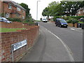
1
West Howe: the start of footpath U35 alongside Moorside Road
While Moorside Road swings round to the left, this public footpath starts in front of us and, after these few yards left-right, runs parallel with the road to the right of the grass, before heading up Ericksen Road just by the tree in the distance. The straight course of this section of path on the Borough's definitive rights of way map is not mirrored by the tarmac on the ground: see Image for the next picture along the path, taken from alongside the white van.
Image: © Chris Downer
Taken: 29 Jun 2016
0.02 miles
2

East Howe: graffiti on footpath U38
Looking down this public footpath to Moorside Road, the wall of garages on the right has become something of a canvas for graffiti artists.
See Image for the next view along the path, round the bend ahead, and Image for the next view behind us, showing the context of the garages.
Image: © Chris Downer
Taken: 28 Jun 2016
0.03 miles
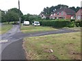
3

East Howe: footpath U38 passes some garages
This public footpath runs down from Kinson Road to Moorside Road, and its first segment is parallel with the driveway to some garages - there was a fence between the two until recently.
See Image for the next view down the path ahead, and Image for the view to here from Kinson Road behind us and discussion of the name Bluebird Walk.
Image: © Chris Downer
Taken: 28 Jun 2016
0.03 miles
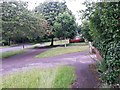
5

West Howe: footpath U38 reaches Moorside Road
Image: © Chris Downer
Taken: 28 Jun 2016
0.04 miles
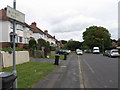
6

West Howe: entering Bluebird Walk from Moorside Road
Many of the footpaths on the West Howe estate and thereabouts have been given names in the last couple of years, a safety initiative whose intention is that, in the event of calling for help, one's location can be more easily described. This one is named Bluebird Walk and is public footpath U38 leading up to Kinson Road.
See Image for a wider view from across the road behind us, and Image for a photo towards us, coming out of the path, with links to further photos along the route.
Image: © Chris Downer
Taken: 28 Jun 2016
0.04 miles
7

West Howe: looking across Moorside Road towards footpath U38
A public footpath comes out just ahead of us, between two houses, from Kinson Road, and is named Bluebird Walk - a recent safety initiative within the Borough saw many alleys and paths named, the idea being that if seeking help, one's location can more easily be given.
See Image for a closer view up the path, with links to further photos on the route.
Image: © Chris Downer
Taken: 26 Feb 2017
0.04 miles
8
West Howe: footpath U35 heads for Ericksen Road
A photo taken on the public footpath, just alongside the white van shown in Image
This public right of way is marked on maps as taking a dead-straight course ahead of us, leading up Ericksen Road behind the red car. However, the tarmacked route strays slightly from absolute straightness.
See Image for a view up Ericksen Road from under the tree on the pavement.
Meanwhile, just to the right ahead is Image
Image: © Chris Downer
Taken: 29 Jun 2016
0.04 miles