IMAGES TAKEN NEAR TO
Stocks Lane, BRADFORD, BD13 2RW
Introduction
This page details the photographs taken nearby to Stocks Lane, BD13 2RW by members of the Geograph project.
The Geograph project started in 2005 with the aim of publishing, organising and preserving representative images for every square kilometre of Great Britain, Ireland and the Isle of Man.

There are currently over 7.5m images from over14,400 individuals and you can help contribute to the project by visiting https://www.geograph.org.uk
Image Map
Images are licensed for reuse under creativecommons.org/licenses/by-sa/2.0
Notes
- Clicking on the map will re-center to the selected point.
- The higher the marker number, the further away the image location is from the centre of the postcode.
Image Listing (46 Images Found)
Images are licensed for reuse under creativecommons.org/licenses/by-sa/2.0
Image
Details
Distance
1
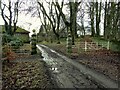
North Gateway to Low House
The dressed stone gate piers would appear to be the entrance to the former Lion Brewery at Low House (from old OS maps). The metal gates to the right were on a track to Low House itself.
Image: © Kevin Waterhouse
Taken: 21 Dec 2022
0.03 miles
2
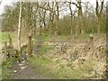
Stile with iron bollard, Clayton
This stile is near to Low House. There is a similar bollard at the other end of this section of path, which goes past thebgrounds of Low House, and another alongside the footbridge over Blackshaw Beck.
Image: © Humphrey Bolton
Taken: 8 Oct 2020
0.04 miles
3
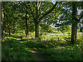
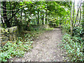
Footpath between trees, Clayton
This is part of a belt of woodland between Stocks Lane and the grounds of Low House, which was a 17C house (probably, as it was sold in 1665) that was demolished before the 1950s. It was sold to Bentleys Breweries and there was a brewery there for a while (disused by 1908).
Image: © Humphrey Bolton
Taken: 19 Sep 2020
0.05 miles
4
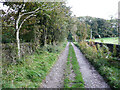
Stocks Lane, Clayton
This is not a through route, apart from footpaths, and seems to have been made to give access to fields. The 1850 six-inch map shows a building at the end, captioned 'Stocks Lane Bottom', implying that the lane was there first. It also shows the lane as passing a house called St Ives.
Image: © Humphrey Bolton
Taken: 8 Oct 2020
0.07 miles
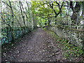
5
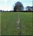
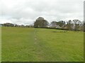
Paved field path
Part of the path from Bobby Green to Low House, which must have been well used to be paved. Now used by the Bronte Way
Image: © Kevin Waterhouse
Taken: 21 Dec 2022
0.07 miles
6
Bradford South Footpath 583 on the lane to Low House, Clayton
This track branches off Stocks Lane.
Image: © Humphrey Bolton
Taken: 8 Oct 2020
0.07 miles
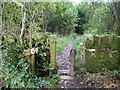
7
Stile with bollards, Clayton
There are several of these curiously-shaped iron bollards, of various sizes, around here. They could be called 'toadstool' bollards or 'helmeted soldier' bollards. Here there are three: daddy toadstool and two little children hoping to trip you. mummy toadstool is at the next stile to the NW and there is another alongside the footbridge over Blackshaw Beck. Were they installed by Clayton Local Board, or the Low House estate?
Image: © Humphrey Bolton
Taken: 19 Sep 2020
0.08 miles
8
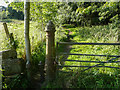
Iron gate at Stocks Lane Bottom
The farm called Stocks Lane Bottom has been demolished, but this ornate gate on its access track (still a public footpath) remains. See also Image
Image: © Stephen Craven
Taken: 12 Mar 2022
0.08 miles
9
A curved wall alongside Stocks Lane, Clayton
This is a puzzling feature. It could perhaps have been made as a passing place, or as an entrance to a gateway that was never made.
Image: © Humphrey Bolton
Taken: 8 Oct 2020
0.08 miles
10
Paved path towards Low House
The path forms part of the Bronte Way, and is probably paved throughout although grass has grown over many of the stones. Such paved paths or 'causeys' are common in Calderdale although this is just over the border into Bradford district.
Image: © Stephen Craven
Taken: 12 Mar 2022
0.09 miles