IMAGES TAKEN NEAR TO
Bath Road, WELLS, BA5 3LN
Introduction
This page details the photographs taken nearby to Bath Road, BA5 3LN by members of the Geograph project.
The Geograph project started in 2005 with the aim of publishing, organising and preserving representative images for every square kilometre of Great Britain, Ireland and the Isle of Man.

There are currently over 7.5m images from over14,400 individuals and you can help contribute to the project by visiting https://www.geograph.org.uk
Image Map
Images are licensed for reuse under creativecommons.org/licenses/by-sa/2.0
Notes
- Clicking on the map will re-center to the selected point.
- The higher the marker number, the further away the image location is from the centre of the postcode.
Image Listing (34 Images Found)
Images are licensed for reuse under creativecommons.org/licenses/by-sa/2.0
Image
Details
Distance
1

The East end of Wells
This row of Edwardian terraced houses are located on the very eastern outskirts of Wells, on the southern side of the old Wells-Bath road.
Image: © Sharon Loxton
Taken: 6 Oct 2007
0.05 miles
2

Barn
A small stone and breeze block barn at the bottom of Knapp hill overlooking the Wells - Bath road.
Image: © Sharon Loxton
Taken: 11 Jun 2006
0.06 miles
3
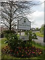
Wells, welcome sign
Sign at the city boundary, junction Bath & Old Frome Roads.
Image: © Mike Faherty
Taken: 12 Apr 2009
0.07 miles
4
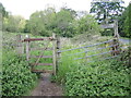
The path up Knapp Hill
A rustic welcome, baling twine and all. The growth spurt of the vegetation makes for slightly more interesting passage now the nettles have woken from their early slumber. Trousers on.
Image: © Neil Owen
Taken: 26 May 2021
0.07 miles
5

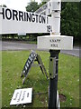
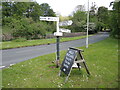
South Horrington, fingerpost
Traditional Somerset fingerpost at the junction of Bath & Old Frome Roads; tapering post with "SOMERSET" in raised letters, and pyramidal finial marked "SCC".
Image: © Mike Faherty
Taken: 12 Apr 2009
0.08 miles
6
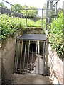
Drain at the bottom of Knapp Hill
The valley running down the hill also has some drainage which empties into this modern culvert. It goes under the Bath Road and on further south.
Image: © Neil Owen
Taken: 26 May 2021
0.08 miles
7
It's Knapp Hill
The signpost on the B3139 is officially Knapp Hill, which is a hill just to the north.
Image: © Neil Owen
Taken: 26 May 2021
0.08 miles
8
Signpost on the B3139
Just outside the fringes of Wells, the B3139 Bath Road heads up the hill towards the Horringtons. The signpost is a typical Somerset type, but being in the Mendip Hills area it also has a triangular collar below the arms: one side is a graphic, another the name of the place and on the third is a grid reference. See Image The greengrocer's board is an additional item.
A couple of odd things is that West Horrington is actually north of South Horrington, and there is no North Horrington.
Image: © Neil Owen
Taken: 26 May 2021
0.08 miles
9
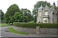
South Lodge to Mendip Hospital
Another view of Image Built about 1845 and described at http://www.britishlistedbuildings.co.uk/en-268200-south-lodge-to-mendip-hospital-st-cuthbe . In the foreground is the Old Frome Road; to the left it meets the B3139 Bath Road.
Image: © Derek Harper
Taken: 16 Aug 2011
0.09 miles
10
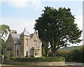
Porter's Lodge, Wells
This building stands at what used to be the main entrance to Mendip Hospital (an asylum) which is located on the eastern outskirts of Wells. The hospital was closed in 1991 and has subsequently been redeveloped and added to, and is now known as St Cuthbert's Village.
Image: © Sharon Loxton
Taken: 6 Oct 2007
0.10 miles