IMAGES TAKEN NEAR TO
Sandridge Road, ST. ALBANS, AL1 4AJ
Introduction
This page details the photographs taken nearby to Sandridge Road, AL1 4AJ by members of the Geograph project.
The Geograph project started in 2005 with the aim of publishing, organising and preserving representative images for every square kilometre of Great Britain, Ireland and the Isle of Man.

There are currently over 7.5m images from over14,400 individuals and you can help contribute to the project by visiting https://www.geograph.org.uk
Image Map (Loading...)


Getting Data...Please wait
Leaflet Map data © OpenStreetMap
Images are licensed for reuse under creativecommons.org/licenses/by-sa/2.0
Notes
- Clicking on the map will re-center to the selected point.
- The higher the marker number, the further away the image location is from the centre of the postcode.
Image Listing (27 Images Found)
Images are licensed for reuse under creativecommons.org/licenses/by-sa/2.0
Image
Details
Distance
1
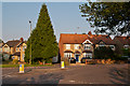
Lancaster Road
Lancaster Road at its junction with Sandridge Road. The road was built in the 1920s/30s, starting at its southern end, and its name is one of a number of road names in the area commemorating the Second Battle of St Albans of 1461, which took place in this part of St Albans.
Image: © Ian Capper
Taken: 25 Jul 2012
0.03 miles
2
Sandridge Road at the junction of Valley Road
Image: © David Howard
Taken: 22 Jul 2014
0.04 miles
3
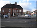
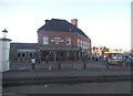
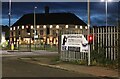
St Albans: The King William IV public house
Situated at the junction of Sandridge Road with Beech Road. Reputedly the father of ten illegitimate children, he seems an odd choice to name a pub after!
Image: © Nigel Cox
Taken: 17 Oct 2007
0.04 miles
4
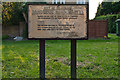
Sandridge Road Wastes
Sign prohibiting parking on the Sandridge Road Wastes, made by byelaws in 1955.
The Sandridge Road Wastes are strips of common land either side of the road originally used for resting and grazing animals prior to market, with the right to use them free of charge having been granted following the Peasants' Revolt in 1381. See Image for a picture of the road showing the Wastes.
The Wastes have been managed by St Albans City Council since 1915.
Image: © Ian Capper
Taken: 25 Jul 2012
0.04 miles
5
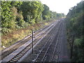
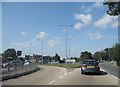
St Albans: Railway line at the Sandridge Road bridge
Viewed looking "up" towards London and St Albans City station, the tracks on the left are for the local stopping trains currently operated by First Capital Connect, and the tracks on the right are for their fast trains and for Midland Mainline's trains to the Midlands.
Image: © Nigel Cox
Taken: 17 Oct 2007
0.05 miles
7
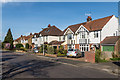
Lancaster Road
1930s housing on a road connecting Sandridge Road and Sandpit Road. The name commemorates one of the sides in the Second Battle of St Albans in 1461, fought on nearby Bernards Heath.
Image: © Ian Capper
Taken: 15 Mar 2014
0.05 miles
8
St Albans : King William IV Pub
Looking towards the pub from Sandridge Road.
Image: © Lewis Clarke
Taken: 27 Apr 2019
0.05 miles
10
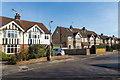
Lancaster Road
1930s housing on a road connecting Sandridge Road and Sandpit Road. The name commemorates one of the sides in the Second Battle of St Albans in 1461, fought on nearby Bernards Heath.
Image: © Ian Capper
Taken: 15 Mar 2014
0.07 miles