IMAGES TAKEN NEAR TO
Monks Close, ST. ALBANS, AL1 2EW
Introduction
This page details the photographs taken nearby to Monks Close, AL1 2EW by members of the Geograph project.
The Geograph project started in 2005 with the aim of publishing, organising and preserving representative images for every square kilometre of Great Britain, Ireland and the Isle of Man.

There are currently over 7.5m images from over14,400 individuals and you can help contribute to the project by visiting https://www.geograph.org.uk
Image Map
Images are licensed for reuse under creativecommons.org/licenses/by-sa/2.0
Notes
- Clicking on the map will re-center to the selected point.
- The higher the marker number, the further away the image location is from the centre of the postcode.
Image Listing (48 Images Found)
Images are licensed for reuse under creativecommons.org/licenses/by-sa/2.0
Image
Details
Distance
1
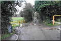
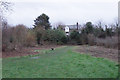
Lane to Sopwell Mill
The public footpath goes through the recreation ground to the left, though that is not instantly obvious.
Image: © Bill Boaden
Taken: 28 Feb 2020
0.07 miles
2

Garages
These garages in Sopwell, just off the Ver-Colne valley walk, do not appear to have seen cars inside them for some time.
Image: © Robert Eva
Taken: 3 Nov 2016
0.08 miles
3
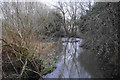
The River Ver near Cottonmill
The river is taking a slow-moving meandering route through a valley which used to have watercress beds.
Image: © Bill Boaden
Taken: 28 Feb 2020
0.08 miles
4
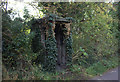
Railway shelter
The old St Albans to Hertford railway is now a pedestrian and cycle path but there are still relics to be seen. This one has almost been reclaimed by nature.
Image: © Robert Eva
Taken: 3 Nov 2016
0.09 miles
5
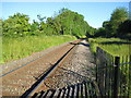
St Albans: The Abbey Flyer line
The London & North Western Railway built their line from Watford Junction to St Albans in 1858. This is the route viewed from Image The train is known locally as the Abbey Flyer.
Image: © Nigel Cox
Taken: 29 May 2009
0.10 miles
6
Open space near the River Ver
A fairly secluded area of open space though it has the Ver-Colne Valley Walk passing through. Sopwell Mill behind is now a private residence.
Image: © Bill Boaden
Taken: 28 Feb 2020
0.10 miles
7
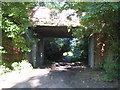
St Albans: Cottonmill Lane railway bridge
Leaving St Albans Abbey station, the former Hatfield and St Albans Railway left the current line to Watford Junction at a point just behind the photographer and this was the first crossing structure that it had to go under. The Great Northern Railway took over the line in 1883, but it was a very early casualty of British Railways' days being closed to passenger traffic in 1951. Freight services lingered on until 1964. The trackbed is now in use as a section of National Cycle Network Route 61 and is the start of the Alban Way, the dedicated footpath and cycleway between St Albans and Hatfield.
Those familiar with Cottonmill Lane will know that it makes a sudden and inexplicable sharp 90 degree turn just to the right of this photograph. Looking at old Ordnance Survey maps it is evident that the road formerly carried straight on to the existing railway, and the re-alignment seems to have occurred when the Berners Drive housing estate to the south was built.
Image: © Nigel Cox
Taken: 29 May 2009
0.12 miles
8
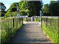
St Albans: Cottonmill Lane pedestrian railway crossing
This crossing over the St Albans Abbey branch line railway allows pedestrians to walk between Cottonmill Lane and Grindcobbe Close.
Image: © Nigel Cox
Taken: 29 May 2009
0.12 miles
9
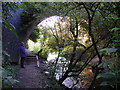
The River Ver passing under a bridge of the Alban Way
The river and footpath both go under the bridge of the disused railway line between St Albans and Hatfield now the footpath/cycle track called The Alban Way
Image: © Peter Constable
Taken: 16 Jul 2000
0.13 miles
10
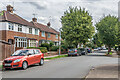
Mentmore Road
c.1930s housing in Mentmore Road, off Cottonmill Lane.
Image: © Ian Capper
Taken: 5 Aug 2021
0.13 miles