IMAGES TAKEN NEAR TO
Cottonmill Lane, ST. ALBANS, AL1 2ES
Introduction
This page details the photographs taken nearby to Cottonmill Lane, AL1 2ES by members of the Geograph project.
The Geograph project started in 2005 with the aim of publishing, organising and preserving representative images for every square kilometre of Great Britain, Ireland and the Isle of Man.

There are currently over 7.5m images from over14,400 individuals and you can help contribute to the project by visiting https://www.geograph.org.uk
Image Map
Images are licensed for reuse under creativecommons.org/licenses/by-sa/2.0
Notes
- Clicking on the map will re-center to the selected point.
- The higher the marker number, the further away the image location is from the centre of the postcode.
Image Listing (38 Images Found)
Images are licensed for reuse under creativecommons.org/licenses/by-sa/2.0
Image
Details
Distance
1
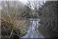
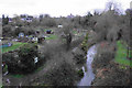
The River Ver near Cottonmill
The river is taking a slow-moving meandering route through a valley which used to have watercress beds.
Image: © Bill Boaden
Taken: 28 Feb 2020
0.04 miles
2
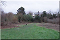
Open space near the River Ver
A fairly secluded area of open space though it has the Ver-Colne Valley Walk passing through. Sopwell Mill behind is now a private residence.
Image: © Bill Boaden
Taken: 28 Feb 2020
0.04 miles
3

Garages
These garages in Sopwell, just off the Ver-Colne valley walk, do not appear to have seen cars inside them for some time.
Image: © Robert Eva
Taken: 3 Nov 2016
0.05 miles
4
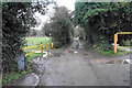
Lane to Sopwell Mill
The public footpath goes through the recreation ground to the left, though that is not instantly obvious.
Image: © Bill Boaden
Taken: 28 Feb 2020
0.05 miles
5
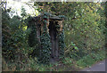
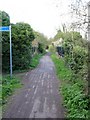
Railway shelter
The old St Albans to Hertford railway is now a pedestrian and cycle path but there are still relics to be seen. This one has almost been reclaimed by nature.
Image: © Robert Eva
Taken: 3 Nov 2016
0.07 miles
6
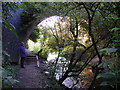
The River Ver passing under a bridge of the Alban Way
The river and footpath both go under the bridge of the disused railway line between St Albans and Hatfield now the footpath/cycle track called The Alban Way
Image: © Peter Constable
Taken: 16 Jul 2000
0.09 miles
7
Nunnery Allotments and the River Ver
Looking down from Alban Way. St Albans Cathedral is seen in the distance.
Image: © Bill Boaden
Taken: 28 Feb 2020
0.13 miles
8
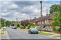
Cottonmill Lane
c.1950s housing in Cottonmill Lane. Although not developed until then, the route itself is much older, being the route from St Albans out to Sopwell from St Albans. In the left background the tower of St Albans Abbey can be seen.
Image: © Ian Capper
Taken: 5 Aug 2021
0.15 miles
9
Cycleway bridge
Looking East over the bridge over the Ver on the St Albans to Hatfield cycleway - an abandoned railway line - at TL153063.
Image: © Rob Hinkley
Taken: 6 Apr 2005
0.15 miles
10
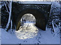
Footpath under a bridge of the Alban Way in winter
This footpath leading to the Verulam golf course and access lane to St Albans fishing club is a continuation of Riverside Road passing under the disused railway line between St Albans and Hatfield Alban Way footpath/cycle track
Image: © Peter Constable
Taken: 31 Jan 2003
0.17 miles