IMAGES TAKEN NEAR TO
Morningside Crescent, INVERURIE, AB51 4FA
Introduction
This page details the photographs taken nearby to Morningside Crescent, AB51 4FA by members of the Geograph project.
The Geograph project started in 2005 with the aim of publishing, organising and preserving representative images for every square kilometre of Great Britain, Ireland and the Isle of Man.

There are currently over 7.5m images from over14,400 individuals and you can help contribute to the project by visiting https://www.geograph.org.uk
Image Map
Images are licensed for reuse under creativecommons.org/licenses/by-sa/2.0
Notes
- Clicking on the map will re-center to the selected point.
- The higher the marker number, the further away the image location is from the centre of the postcode.
Image Listing (17 Images Found)
Images are licensed for reuse under creativecommons.org/licenses/by-sa/2.0
Image
Details
Distance
1
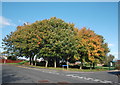
Suburban corner (autumn trees)
Gordon Terrace meets Brankie Road in the endless Inverurie suburbs.
Image: © Bill Harrison
Taken: 30 Sep 2017
0.11 miles
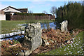
2
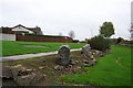
Brandsbutt Stone Circle
Some of the Pictish stones that were recovered from a stone dyke in 1900. The circle was destroyed many years before. They now lie surrounded by a new housing scheme.
Image: © stephen samson
Taken: 20 Oct 2006
0.12 miles
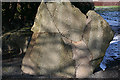
3
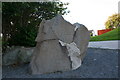
Brandsbutt Stone
A stone of many pieces this Pictish stone was recovered from farmland as pieces and carefully reassembled.
Image: © Andrew Wood
Taken: 6 Oct 2008
0.12 miles
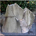
4
Brandsbutt Stone
The Brandsbutt stone bears Pictish carvings and an Ogham inscription. It was found broken into pieces in a field was but has been reassembled. See https://canmore.org.uk/site/18894/brandsbutt-inverurie-symbol-stone for more information.
Image: © Anne Burgess
Taken: 25 Feb 2016
0.12 miles
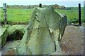
5
Brandsbutt Stone
The stone is a Class 1 stone, which means that it has incised symbols but no cross or relief carving. The symbols are a serpent and Z-rod, and above it a crescent and V-rod. On the left-hand edge of the stone there is an Ogham inscription. See https://canmore.org.uk/site/18894/brandsbutt-inverurie-symbol-stone for more information.
Image: © Anne Burgess
Taken: 25 Feb 2016
0.12 miles
6
Another view of the Brandsbutt Stone
This fine symbol stone was blown up in the 19th Century and the fragments used to construct a dyke but most of it was later reassembled with cement infills. Until recently it was in open farmland, but is now surrounded by suburban housing. It is decorated with Pictish crescent and V-rod and a serpent and Z-rod symbols as well as Ogam characters. Canmore reference 18894: https://canmore.org.uk/site/18894/brandsbutt-inverurie-symbol-stone . For more, see Allen and Anderson, Early Christian Monuments of Scotland, vol. 3, p. 506, available as a download from archive.org
Image: © Bill Harrison
Taken: 30 Sep 2017
0.12 miles
7
Brandsbutt Class I Pictish Symbol Stone
Photograph taken when the stood in a field. https://www.megalithic.co.uk/article.php?sid=7105
Image: © Sandy Gerrard
Taken: Unknown
0.12 miles
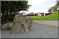
8
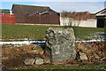
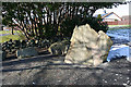
Douping Stone
This is one of the stones that made up the stone circle beside the Brandsbutt Stone. It and its fellow had been built into a field wall, but when the area was redeveloped as housing they were re-erected beide the Brandsbutt Stone. It is named on the 1:25,000 map as 'Douping Stone' but I have not found any explanation for this. https://canmore.org.uk/site/18882/brandsbutt for more information.
Image: © Anne Burgess
Taken: 25 Feb 2016
0.12 miles
9
Brandsbutt Stone Circle
These two stones, plus the symbol stone a few metres away in the next square, are the remains of a stone circle. According to the 1:25,000 map the nearer one is called the Douping Stone, but I have not found any explanation of this. See https://canmore.org.uk/site/18882/brandsbutt for more information.
Image: © Anne Burgess
Taken: 25 Feb 2016
0.12 miles
10
The Brandsbutt Pictish Stone
Broken and re-assembled.
It bears several standard symbols found on pictish stones including:
a V rod, a Z rod a crescent and a serpent.
In addition there is an ogham inscription: IRATADDOARENS
thought to mean Eddarrnon, possibly St. Ethernanus.
Image: © Bob Embleton
Taken: 11 Aug 2011
0.12 miles