IMAGES TAKEN NEAR TO
Wragby Close, WOLVERHAMPTON, WV9 5LH
Introduction
This page details the photographs taken nearby to Wragby Close, WV9 5LH by members of the Geograph project.
The Geograph project started in 2005 with the aim of publishing, organising and preserving representative images for every square kilometre of Great Britain, Ireland and the Isle of Man.

There are currently over 7.5m images from over14,400 individuals and you can help contribute to the project by visiting https://www.geograph.org.uk
Image Map
Images are licensed for reuse under creativecommons.org/licenses/by-sa/2.0
Notes
- Clicking on the map will re-center to the selected point.
- The higher the marker number, the further away the image location is from the centre of the postcode.
Image Listing (98 Images Found)
Images are licensed for reuse under creativecommons.org/licenses/by-sa/2.0
Image
Details
Distance
1

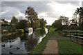
Staffordshire and Worcestershire Canal near Pendeford, Wolverhampton
Looking north-east towards Marsh Lane Bridge, No 67.
Image: © Roger Kidd
Taken: 19 Apr 2013
0.03 miles
2
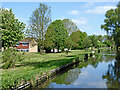
Heron walk
The view by the Staffordshire and Worcestershire Canal near Marsh lane Bridge at Pendeford.
Image: © Gordon Griffiths
Taken: 28 Sep 2020
0.03 miles
3
The Staffordshire & Worcestershire Canal south of Marsh Lane Bridge
After The Narrows to the north, the canal broadens out again. There is a large congregation of ducks.
Image: © Bill Boaden
Taken: 10 Nov 2016
0.03 miles
4
Canal and parkland near Pendeford in Wolverhampton
Looking north towards Marsh Lane Bridge, this shows the Staffordshire and Worcestershire Canal. Open parkland and housing estates to the left were developed on the former Wolverhampton Municipal Airport. Sustrans Route 81 passes along the towpath.
Image: © Roger Kidd
Taken: 14 May 2016
0.04 miles
5

Staffordshire and Worcestershire Canal near Pendeford, Wolverhampton
Looking north-east towards Marsh Lane Bridge, No 67. Housing off to the left is in Waterside Way, Clewley Drive and Wragby Close.
Image: © Roger Kidd
Taken: 19 Apr 2013
0.04 miles
6

Staffordshire and Worcestershire Canal near Pendeford, Wolverhampton
Looking north-east towards Marsh Lane Bridge, No 67.
Image: © Roger Kidd
Taken: 19 Apr 2013
0.04 miles
7
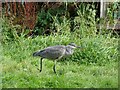
Marsh Harrier
The view over the Staffordshire and Worcestershire Canal near Marsh lane Bridge at Pendeford.
A heron hides in the grass.
Image: © Gordon Griffiths
Taken: 28 Sep 2020
0.05 miles
8
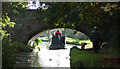
Marsh Lane Bridge (3), Wolverhampton
Marsh Lane Bridge is at the southern end of a narrow part of the Staffordshire and Worcestershire Canal. The bridge is also deceptively low on the non-towpath side of the bridge hole. Boat tillermen should always steer near to the towpath when negotiating the bridge. This one, on quite a low boat, has negotiated safely, but it is from the other direction that mistakes are more often made on the entry bend, especially with the many boats which stand higher out of the water! :-)
The narrows are cut into the sandstone rock, and for half a mile or so narrowboats cannot pass each other. There are two wider spots in the narrows where one (maybe two) boat(s) can pass another coming the other way. The latest Nicholson Guide mentions that locally the stretch is called "Pendeford Rockin'", after a local farm.
Image: © Roger D Kidd
Taken: 16 Oct 2008
0.05 miles
9
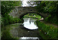
Marsh Lane Bridge at Fordhouses, Wolverhampton
On the Staffordshire and Worcestershire Canal travelling south, this bridge marks the end of the gloomy tree enshrouded "narrows", much of which do not allow boats to pass each other. The bridge carries a public footpath between Marsh Lane (vehicular) and Pendeford Lane (footpath).
Image: © Roger D Kidd
Taken: 19 May 2009
0.06 miles
10
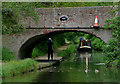
Marsh Lane Bridge and Narrows, near Wolverhampton
A narrowboat is approaching very slowly from the narrow cutting in the sandstone where, apart from a couple of short passing places, the canal is much less than the width of two boats. It is gloomy and green in the cutting, but hardly warranting use of the headlight - or was he just making sure we knew he was coming? The traffic cone is not a fixed feature, but adds colour, and the photographer adds interest to the picture too - secret Geograph hunter maybe - I await his picture :-)
Sequence: passage north through the narrows, #1. Next image is Image]
Image: © Roger D Kidd
Taken: 26 May 2009
0.06 miles