IMAGES TAKEN NEAR TO
Holyhead Road, WOLVERHAMPTON, WV7 3AP
Introduction
This page details the photographs taken nearby to Holyhead Road, WV7 3AP by members of the Geograph project.
The Geograph project started in 2005 with the aim of publishing, organising and preserving representative images for every square kilometre of Great Britain, Ireland and the Isle of Man.

There are currently over 7.5m images from over14,400 individuals and you can help contribute to the project by visiting https://www.geograph.org.uk
Image Map
Images are licensed for reuse under creativecommons.org/licenses/by-sa/2.0
Notes
- Clicking on the map will re-center to the selected point.
- The higher the marker number, the further away the image location is from the centre of the postcode.
Image Listing (39 Images Found)
Images are licensed for reuse under creativecommons.org/licenses/by-sa/2.0
Image
Details
Distance
1
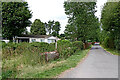
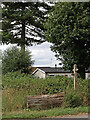
Lane and bridleway in Kingswood, Staffordshire
This is where the private farm road (and bridleway) from Wrottesley Lodge continues into the village (A464 Holyhead Road) with a mobile homes park on the left and a small modern business park off to the right.
Also off to the right is the bridleway south-east to The Bradshaws. It continues off to the left to Holyhead Road, unsurfaced and more overgrown.
Image: © Roger Kidd
Taken: 1 Aug 2022
0.03 miles
2
Crossroads of bridleways
Unfortunately, someone had parked a Land Rover across part of it, so I struggled to get the whole thing in. This is pretty much the opposite view to that in Image
Image: © Richard Law
Taken: 8 Jul 2009
0.04 miles
3
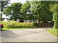
Bridleways junction at Kingswood in Staffordshire
Although the private farm roads have good surfaces here, they are also public bridleways approaching Kingswood from the former Wrottesley estate.
There is a small mobile homes park off to the left, and a modern "business park" ahead and on the right.
The bridleway behind the camera leads to Wrottesley Lodge Farm. The one leading off to the right goes towards The Bradshaws and Wrottesley Hall.
Image: © Roger Kidd
Taken: 1 Aug 2022
0.04 miles
4
Crossroads View
The view of the paths junction at Kingswood Caravan Park.
Image: © Gordon Griffiths
Taken: 13 Mar 2017
0.04 miles
5
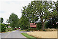
Bridleway junction in Kingswood, Staffordshire
The rather overgrown bridleway off to the left leads to the A464 Holyhead Road. Off to the right and better maintained, it leads south-eastwards towards The Bradshaws and Wrottesley Hall. Back and off to the left is the private farm road (also bridleway) to Wrottesley Lodge.
Image: © Roger Kidd
Taken: 1 Aug 2022
0.04 miles
6
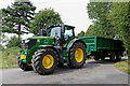
Harvest tractor near Kingswood in Staffordshire
Most nearby fields are covered with wheat and barley (some oats, potatoes and rape). Crops are ready early this year because of extended warm (sometimes very hot) and dry weather.
Image: © Roger Kidd
Taken: 1 Aug 2022
0.05 miles
7
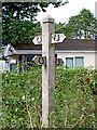
Bridleway signpost in Kingswood, Staffordshire
Two bridleways cross the former Wrottesley estate, then cross each other here.
Back and left to Wrottesley Lodge and Wrottesley Old Park.
Forward and left to the A464 Shifnal Road.
Back and right to The Bradshaws and Wrottesley Park.
Forward and right to the A464 Shifnal Road.
The Wrottesley Estate in Staffordshire existed from the 13th century but was sold off to its tenants in 1963. Wrottesley Park and Wrottesley Old Park remain as marked areas on many maps. Most of the land is used for wheat and barley with some oats, rape and potatoes. There are several small plantations of trees, and a larger one away to the west in (Patshull) High Park. Not all the farm roads and tracks in these parks have a public right of way.
Image: © Roger Kidd
Taken: 1 Aug 2022
0.05 miles
8
Bridleway in Kingswood, Staffordshire
Looking west-north-west towards the A464 Shifnal Road, and seen from the junction with the bridleway from Wrottesley Lodge Farm.
Victorian maps label this as Old Road. It appears to have been part of a cul-de-sac leading from Shifnal Road to Simmonds's Wood about 850 metres to the south-east, and presumably to service the old coach house, which is still there.
Image: © Roger Kidd
Taken: 1 Aug 2022
0.05 miles
9
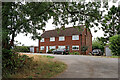
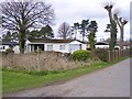
Semi-detached houses in Kingswood, Staffordshire
The houses are by the bridleways near Kingswood Bank Farm.
Image: © Roger Kidd
Taken: 1 Aug 2022
0.06 miles
10
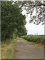
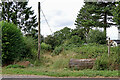
Bridleway near Kingswood in Staffordshire
Looking south-east towards The Bradshaws and Wrottesley Hall. The bridleway is only surfaced as far as The Coach House (recently renovated) about three hundred metres ahead.
Victorian maps label this as Old Road, but it only appears to go as far as Simmonds's Wood 900 metres (about 983 yards) ahead.
Image: © Roger Kidd
Taken: 1 Aug 2022
0.07 miles