IMAGES TAKEN NEAR TO
Great Moor Road, WOLVERHAMPTON, WV6 7AU
Introduction
This page details the photographs taken nearby to Great Moor Road, WV6 7AU by members of the Geograph project.
The Geograph project started in 2005 with the aim of publishing, organising and preserving representative images for every square kilometre of Great Britain, Ireland and the Isle of Man.

There are currently over 7.5m images from over14,400 individuals and you can help contribute to the project by visiting https://www.geograph.org.uk
Image Map
Images are licensed for reuse under creativecommons.org/licenses/by-sa/2.0
Notes
- Clicking on the map will re-center to the selected point.
- The higher the marker number, the further away the image location is from the centre of the postcode.
Image Listing (30 Images Found)
Images are licensed for reuse under creativecommons.org/licenses/by-sa/2.0
Image
Details
Distance
1
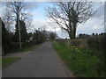
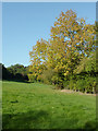
Lane with houses on one side only
Strip development near Nurton. To the right is green belt between Wolverhampton and the villages to the west.
Image: © Row17
Taken: 27 Mar 2009
0.04 miles
2
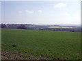
Sloping field
The field slopes down towards the woodland. The Monarch's and Staffordshire Ways climb out from the valley on to the Perton Ridge.
Image: © John M
Taken: 7 Apr 2007
0.13 miles
3
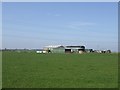
Farm in countryside
Last property on an extension of the Perton Ridge above Great Moor.
Image: © John M
Taken: 7 Apr 2007
0.18 miles
4
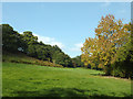
Pasture near Nurton, Staffordshire
Among the trees on the right is the bridleway known as Toadnest Lane, used by both The Staffordshire Way and The Monarch's Way.
Image: © Roger D Kidd
Taken: 10 Oct 2010
0.18 miles
5
Pasture near Nurton, Staffordshire
Among the trees on the right is the bridleway known as Toadnest Lane, used by both The Staffordshire Way and The Monarch's Way.
Image: © Roger D Kidd
Taken: 10 Oct 2010
0.18 miles
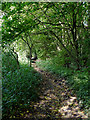
6
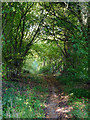
Bridleway near Nurton, Staffordshire
The Staffordshire Way and the Monarch's Way both use this bridleway, known as Toadnest Lane.
The establishment of the Staffordshire Way was completed in 1983 and was the first of the two such long distance footpaths to be created in Staffordshire, (the other being the Way for the Millennium). The Staffordshire Way spans the length of the County for 92 miles (about 148 kilometres) from Mow Cop in the north to Kinver Edge in the south.
The Monarch's Way is a 615-mile (990 km) long-distance footpath in England that approximates the escape route taken by King Charles II in 1651 after being defeated in the Battle of Worcester. http://en.wikipedia.org/wiki/Monarch%27s_Way
Image: © Roger D Kidd
Taken: 10 Oct 2010
0.19 miles
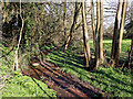
7
Two Ways
The Staffordshire Way and the Monarch's Way runs North.
Image: © Gordon Griffiths
Taken: 25 Jan 2008
0.22 miles
8
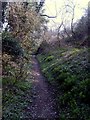
Monarch's Way
The Footpath is shared with the Staffordshire Way.
Image: © Gordon Griffiths
Taken: 20 Mar 2009
0.22 miles
9
Nurton Brook east of Pattingham in Staffordshire
Looking upstream towards Nurton. A very pleasant and secluded public footpath through pasture and woodland crosses the stream on a footbridge here. Nurton Brook flows south (towards the camera), joins Black Brook, which in turn flows into Smestow Brook, then the River Stour, and the River Severn near Stourport. This image shows the brook after a period of unusually warm dry spring weather.
Image: © Roger Kidd
Taken: 29 Mar 2019
0.22 miles
10
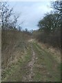
Bridleway east of Nurton, Staffordshire
The Staffordshire Way and the Monarch's Way both use this bridleway, known as Toadnest Lane.
The establishment of the Staffordshire Way was completed in 1983 and was the first of the two such long distance footpaths to be created in Staffordshire, (the other being the Way for the Millennium). The Staffordshire Way spans the length of the County for 92 miles (about 148 kilometres) from Mow Cop in the north to Kinver Edge in the south.
The Monarch's Way is a 615-mile (990 km) long-distance footpath in England that approximates the escape route taken by King Charles II in 1651 after being defeated in the Battle of Worcester. http://en.wikipedia.org/wiki/Monarch%27s_Way
Image: © Roger D Kidd
Taken: 10 Oct 2010
0.23 miles