IMAGES TAKEN NEAR TO
Holloway, WOLVERHAMPTON, WV5 7DD
Introduction
This page details the photographs taken nearby to Holloway, WV5 7DD by members of the Geograph project.
The Geograph project started in 2005 with the aim of publishing, organising and preserving representative images for every square kilometre of Great Britain, Ireland and the Isle of Man.

There are currently over 7.5m images from over14,400 individuals and you can help contribute to the project by visiting https://www.geograph.org.uk
Image Map
Images are licensed for reuse under creativecommons.org/licenses/by-sa/2.0
Notes
- Clicking on the map will re-center to the selected point.
- The higher the marker number, the further away the image location is from the centre of the postcode.
Image Listing (35 Images Found)
Images are licensed for reuse under creativecommons.org/licenses/by-sa/2.0
Image
Details
Distance
1
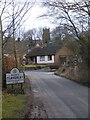
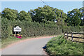
Entering Claverley
The view of the Village as you enter from the North.
Image: © Gordon Griffiths
Taken: 26 Feb 2010
0.07 miles
2
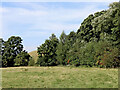
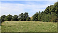
Pasture and woodland north-west of Claverley
Looking north-west from Digbeth Lane (also mapped as Hopstone Road).
Image: © Roger Kidd
Taken: 8 Sep 2021
0.07 miles
3
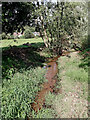
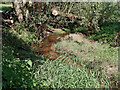
Small brook near Claverley in Shropshire
Looking north from Digbeth Lane (or Hopstone Road).
I'm not sure if this is Claverley Brook, but if it is not, it flows into Claverley Brook/Danford Brook about two hundred metres to the north-east.
Image: © Roger Kidd
Taken: 8 Sep 2021
0.08 miles
4
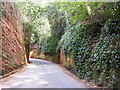
Claverley Cutting
The road leaving Claverley north cuts through a sandstone cliff.
Image: © Gordon Griffiths
Taken: 11 Aug 2012
0.08 miles
5
Pasture and woodland north-west of Claverley
Looking north-west from Digbeth Lane (also mapped as Hopstone Road). Claverley Brook flows away from the camera at the far end of the field.
Image: © Roger Kidd
Taken: 8 Sep 2021
0.09 miles
6
Small brook near Claverley in Shropshire
Looking north-east from Digbeth Lane (or Hopstone Road).
I'm not sure if this is Claverley Brook, but if it is not, it flows into Claverley Brook/Danford Brook about two hundred metres to the north-east.
Image: © Roger Kidd
Taken: 8 Sep 2021
0.09 miles
7
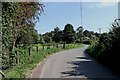
Digbeth Lane approaching Claverley in Shropshire
Some maps label this as Hopstone Road. This is the view looking south-east towards the junction with Church Street.
Image: © Roger Kidd
Taken: 8 Sep 2021
0.09 miles
8
Lane to Upper Ludstone in Shropshire
At the north end of Church Street in Claverley is the junction where Digbeth Lane (or Hopstone Road; maps can't agree) leads off to the left.
Image]
Image: © Roger Kidd
Taken: 8 Sep 2021
0.09 miles
9
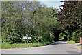
Welcome to Claverley in Shropshire
This is the approach from the north-west. Most maps call it Digbeth Lane, but others name it Hopstone Road.
Image]
Image: © Roger Kidd
Taken: 8 Sep 2021
0.10 miles
10
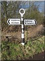
Old Direction Sign - Signpost by Hopstone Road, Claverley Parish
Annulus finial - 2 arms (new); Shropshire CC shield and halo by the UC road, in parish of Claverley (Bridgnorth District), Digbeth Lane/Hopstone Road junction with Church Street.
Surveyed
Milestone Society National ID: SA_SO7993
Image: © Milestone Society
Taken: Unknown
0.10 miles