IMAGES TAKEN NEAR TO
Claverley, WOLVERHAMPTON, WV5 7AN
Introduction
This page details the photographs taken nearby to WV5 7AN by members of the Geograph project.
The Geograph project started in 2005 with the aim of publishing, organising and preserving representative images for every square kilometre of Great Britain, Ireland and the Isle of Man.

There are currently over 7.5m images from over14,400 individuals and you can help contribute to the project by visiting https://www.geograph.org.uk
Image Map
Images are licensed for reuse under creativecommons.org/licenses/by-sa/2.0
Notes
- Clicking on the map will re-center to the selected point.
- The higher the marker number, the further away the image location is from the centre of the postcode.
Image Listing (17 Images Found)
Images are licensed for reuse under creativecommons.org/licenses/by-sa/2.0
Image
Details
Distance
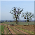
2
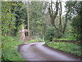
Parkland, Gatacre
With some fine specimen trees.
Image: © Richard Webb
Taken: 18 Jul 2019
0.16 miles
3
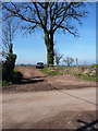
Parked on a bridleway
Well, technically, the car's parked just off the side of the bridleway, not blocking it; the bridleway splits a little way into the field, and the branches lead to farms at Lower and Upper Beobridge.
Image: © Richard Law
Taken: 6 Apr 2015
0.18 miles
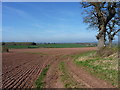
4
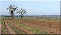
Farm track, Gatacre
Beside a field of oats and showing up the sandy soil here.
Image: © Richard Webb
Taken: 18 Jul 2019
0.19 miles
5
Track and oak trees near Beobridge, Worcestershire
The (Triassic) Bunter Sandstone underlying rock gives the reddish colour to the sandy soil. Claverley is beyond the oak tree on the right, about one and a half miles (2.5 km) north. The bridleway along this track divides by the trees, going north-west to Lower Beobridge, and north-north-west towards Honeybourne Grange and Upper Beobridge.
Image: © Roger D Kidd
Taken: 16 Mar 2010
0.19 miles
6
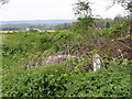
Overgrown Sign
The sign for Upper and Lower Beobridge south of Claverley, Shropshire.
Image: © Gordon Griffiths
Taken: 10 May 2010
0.19 miles
7
The bridleway from Sytch House Green to Broad Oak
Rather overgrown at this time of year, but at least it's only grass, so easy enough to walk or ride through. Others in the area are a tangle of nettles and brambles, and thus a lot less user friendly.
Image: © Richard Law
Taken: 9 Aug 2012
0.20 miles
8
Bridleway junction in a field
The bifurcation of bridleways - left (along the faint grassy track) leads to Beobridge Grange and Lower Beobridge, whilst the right fork leads to Upper Beobridge.
Image: © Richard Law
Taken: 6 Apr 2015
0.21 miles
9
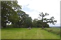
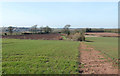
Fields towards Beobridge, Shropshire
The buildings around Honeybourne Grange are in the centre of the picture about half a mile (about eight hundred metres) distant. The (Triassic) Bunter Sandstone underlying rock gives the reddish colour to the sandy soil. Claverley is beyond the oak tree on the right, about one and a half miles (2.5 km) north.
Image: © Roger D Kidd
Taken: 16 Mar 2010
0.21 miles
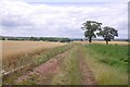
10
Bridleway to Lower Beobridge, Shropshire
The bridleway crosses the crop field here and enters a narrow bush enclosed lane to the right of the apparent green way in the mid distance, which is not the route; it is just an uncultivated field border. Comparing the current Google satellite images with today's observations shows the fields around here are commonly rotated between potatoes, cereals and rape.
The Wrekin can be seen centrally on the skyline about twelve miles away.
Image: © Roger D Kidd
Taken: 16 Mar 2010
0.21 miles