IMAGES TAKEN NEAR TO
Lower Beobridge, Claverley, WOLVERHAMPTON, WV5 7AH
Introduction
This page details the photographs taken nearby to WV5 7AH by members of the Geograph project.
The Geograph project started in 2005 with the aim of publishing, organising and preserving representative images for every square kilometre of Great Britain, Ireland and the Isle of Man.

There are currently over 7.5m images from over14,400 individuals and you can help contribute to the project by visiting https://www.geograph.org.uk
Image Map
Images are licensed for reuse under creativecommons.org/licenses/by-sa/2.0
Notes
- Clicking on the map will re-center to the selected point.
- The higher the marker number, the further away the image location is from the centre of the postcode.
Image Listing (11 Images Found)
Images are licensed for reuse under creativecommons.org/licenses/by-sa/2.0
Image
Details
Distance
1
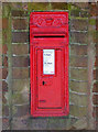
Victorian postbox at Lower Beobridge, Shropshire
No doubt the owners of Beobridge Grange insisted on their own personal post box.
Image: © Roger D Kidd
Taken: 16 Mar 2010
0.01 miles
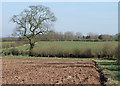
2
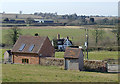
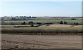
Farmland at Lower Beobridge, Shropshire
Considerable modernisation and recent conversion has been done at and around Beobridge Grange (off to the right, not the black and white building in the centre). The bridleway which climbs the hill south of the buildings has been re-routed so does not coincide exactly with current maps.
Farmcote Farm can be seen about three quarters of a mile to the west-north-west.
Image: © Roger D Kidd
Taken: 17 Mar 2010
0.06 miles
3
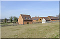
Farm land at Lower Beobridge, Shropshire
Considerable modernisation and recent conversion has been done at and around Beobridge Grange. The bridleway which climbs the hill south of the buildings has been re-routed so does not coincide exactly with current maps.
Image: © Roger D Kidd
Taken: 16 Mar 2010
0.07 miles
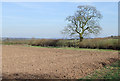
4
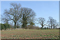
Arable land near Lower Beobridge, Staffordshire
Following a long cold winter (night frosts until a day or so before this photograph) this rape crop is several weeks behind in its spring growth.
The bridleway from the road to here has been diverted further away from Beobridge Grange, and current maps do not show this.
Image: © Roger D Kidd
Taken: 16 Mar 2010
0.13 miles
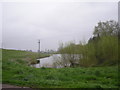
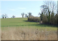
6
Cut hay and a large pool in the valley of the Claverley Brook
Image: © Richard Law
Taken: 9 Aug 2012
0.20 miles
7
Arable land near Lower Beobridge, Shropshire
A freshly planted(?) potato field, looking north-east towards Beobridge. The current Google satellite image and today's photographs suggest that many of the fields here are rotated between potato, rape, or a cereal crop.
Image: © Roger D Kidd
Taken: 17 Mar 2010
0.20 miles
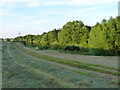
8
Arable land near Lower Beobridge, Shropshire
The bridleway is to the right just off the picture. Looking at the current Google satellite image and today's photographs, it seems that fields here are rotated between potato, rape, or a cereal crop.
Image: © Roger D Kidd
Taken: 17 Mar 2010
0.22 miles
9
Farm land south of Claverley, Shropshire
Not much grass or crop growth has occurred during a long cold winter. Night frosts have persisted until just a day or so before this picture was taken. There is little green about.
Here's a 2007 image taken just three weeks later in the year: Image
Image: © Roger D Kidd
Taken: 16 Mar 2010
0.23 miles
10
Arable land near Lower Beobridge, Shropshire
The bridleway towards Gatacre is within the line of bushes on the right. The current Google satellite image (showing the yellow of a rape crop) and today's photographs suggest that many of the fields here are rotated between potato, rape, or as today, a cereal crop.
Image: © Roger D Kidd
Taken: 16 Mar 2010
0.24 miles