IMAGES TAKEN NEAR TO
Whittington, WORCESTER, WR5 2RW
Introduction
This page details the photographs taken nearby to WR5 2RW by members of the Geograph project.
The Geograph project started in 2005 with the aim of publishing, organising and preserving representative images for every square kilometre of Great Britain, Ireland and the Isle of Man.

There are currently over 7.5m images from over14,400 individuals and you can help contribute to the project by visiting https://www.geograph.org.uk
Image Map
Images are licensed for reuse under creativecommons.org/licenses/by-sa/2.0
Notes
- Clicking on the map will re-center to the selected point.
- The higher the marker number, the further away the image location is from the centre of the postcode.
Image Listing (45 Images Found)
Images are licensed for reuse under creativecommons.org/licenses/by-sa/2.0
Image
Details
Distance
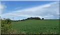
1
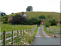
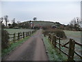
Whittington Tump
A small hill with a solitary tree visible from miles around. Crookbarrow Farm is seen in front.
Image: © Chris Allen
Taken: 4 Jul 2021
0.05 miles
2
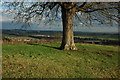
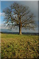
Tree on Whittington Tump
The trunk of the tree on Whittington Tump with two bridges on the M5 motorway in the background.
Image: © Philip Halling
Taken: 13 Dec 2009
0.07 miles
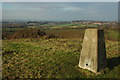
3
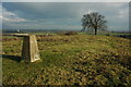
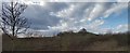
On top of Whittington Tump or Crookbarrow Hill
View to the north-east from the trig point on top of Whittington Tump or Crookbarrow Hill. A bridge over the M5 motorway can be seen above the trig point, with the sun lighting Spetchley Hall in the distance. With its tree on the summit this 86m high hill is a prominent feature for travellers passing junction 7 on the M5 motorway. There is still debate as to whether this is a natural or man-made hill. There is a myth that it is a burial site from the Battle of Worcester (1651), however, some archaeologists believe it may be a very large ancient burial barrow. No archaeology dig has ever taken place on the site.
Image: © Philip Halling
Taken: 13 Dec 2009
0.07 miles
4
Crookbarrow Hill
Behind Crookbarrow Farm. On top of this tump is a well known landmark for M5 users - a chestnut tree (according to our Geocache cousins).
Image: © Bob Embleton
Taken: 19 Sep 2005
0.07 miles
5
Crookbarrow Hill, Whittington, Worcester
A familiar landmark to anyone passing this area on the motorway or other roads and all the more fascinating due to the lone tree on its crown.
Image: © Jeremy Bolwell
Taken: 6 Dec 2012
0.08 miles
6
Tree on Whittington Tump or Crookbarrow Hill
Whittington Tump or Crookbarrow Hill with this tree on its summit is just 86m above sea level but is a prominent feature for anyone travelling on the M5 motorway near junction 7.
Image: © Philip Halling
Taken: 13 Dec 2009
0.08 miles
7
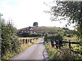
Crookbarrow Hill or Whittington Tump
This is a partly artificial mound in Worcestershire. There is evidence of pre-historic activity at the site and some sources say it was fortified by the Romans (a Romano-British settlement has also been found nearby). The site came to prominence during the Anglo-Saxon era when a settlement was established. In the mediaeval period, a manor house was established next to the hill and a motte castle constructed atop it. The castle has since disappeared and the area returned to agricultural use. The site was listed as a scheduled monument in 1923.
Image: © Anthony Parkes
Taken: 6 Mar 2020
0.08 miles
8
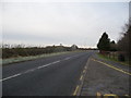
Crookbarrow Hill from beside the B4084 east of the M5
The eyecatching little hillock and its lone tree always grabs my attention.
Image: © Jeremy Bolwell
Taken: 6 Dec 2012
0.08 miles
9
Whittington Tump
Seen from a unfamilar side along the remnant footpath .
Image: © Andrew Darge
Taken: 10 Apr 2012
0.08 miles
10
Trig point on Whittington Tump or Crookbarrow Hill
View to the north-west from beside the trig point on Whittington Tump or Crookbarrow Hill. With its single tree Whittington Tump is a distinctive landmark when passing junction 7 on the M5 motorway. The city of Worcester is to the left of centre in the middle distance, the cathedral tower and St Andrew's spire can be seen along with the tower blocks in St Johns, the Abberley Hill are on the horizon.
Image: © Philip Halling
Taken: 13 Dec 2009
0.09 miles