IMAGES TAKEN NEAR TO
Woodpeckers Lane, WORCESTER, WR5 1TD
Introduction
This page details the photographs taken nearby to Woodpeckers Lane, WR5 1TD by members of the Geograph project.
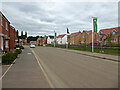
The Geograph project started in 2005 with the aim of publishing, organising and preserving representative images for every square kilometre of Great Britain, Ireland and the Isle of Man.

There are currently over 7.5m images from over14,400 individuals and you can help contribute to the project by visiting https://www.geograph.org.uk
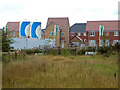
Image Map
Images are licensed for reuse under creativecommons.org/licenses/by-sa/2.0
Notes
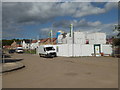
- Clicking on the map will re-center to the selected point.
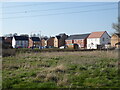
- The higher the marker number, the further away the image location is from the centre of the postcode.
Image Listing (246 Images Found)
Images are licensed for reuse under creativecommons.org/licenses/by-sa/2.0
Image
Details
Distance
1
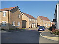
Woodpeckers Lane, Whittington Walk
A new housing development. This was the first time I had spotted this particular named street.
Image: © Chris Allen
Taken: 20 Mar 2022
0.02 miles
2
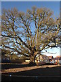
Oak Turn, Whittington Walk housing development
An original tree preserved within a large new housing development. The road around it is called Oak Turn. The tree is easy enough to locate but the photographer position and view direction are best guesses.
Image: © Chris Allen
Taken: 25 Dec 2019
0.02 miles
3
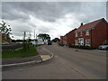
Swinesherd Lane
New housing development, Swinesherd.
Image: © JThomas
Taken: 12 Aug 2021
0.04 miles
4
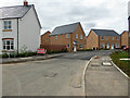
Whittington Walk housing development, Worcester
As far as I can work out, Heron End is the road to the left in front of the white house. The road ahead and curving to the right is Skylark Rise. Fresh tarmac has been laid on Skylark Rise as work progresses on finishing this part of the still expanding development.
Image: © Chris Allen
Taken: 18 Aug 2021
0.04 miles
5
Whittington Walk housing development, Worcester
A view of the phase 2 development from an angle that I had not previously used. The access road to phase 3 leads off the left hand edge. The contractors' car park is to the right.
Image: © Chris Allen
Taken: 20 Mar 2022
0.04 miles
6
Whittington Walk housing development, Worcester
The houses in the background are finished and occupied but the complex is still growing and the silos remain in use. In the foreground is part of a sustainable urban drainage system (SUDS).
Image: © Chris Allen
Taken: 25 Sep 2021
0.04 miles
7
Whittington Walk housing development, Worcester
This is Swinesherd Way that was the earliest part of this large and still burgeoning development.
Image: © Chris Allen
Taken: 18 Aug 2021
0.04 miles
8
Whittington Walk housing development, Worcester
This is Swinesherd Way by the contractor's compound. To the left is a mixture of completed houses and houses under construction while behind the photographer is contractor only access to unfinished houses. This is going to be a big complex. What strikes you while walking around developments on a weekend is just how there are virtually no other people on foot - you see people in houses and gardens, and people in vehicles but I was alone in actually covering the ground on foot.
Image: © Chris Allen
Taken: 22 Aug 2020
0.04 miles
9
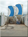
Whittington Walk construction site
Part of the building site for the new Whittington Walk housing development. These two silos are on Swinesherd Lane. Last time I photographed them it was a weekend and the gates were closed, hiding the bottom of the silos.
Image: © Chris Allen
Taken: 10 Jun 2021
0.04 miles
10
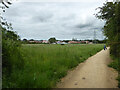
Whittington Walk from the bridleway
The new housing development that is still being constructed as seen from the bridleway paralleling the M5.
Image: © Chris Allen
Taken: 10 Jun 2021
0.04 miles