IMAGES TAKEN NEAR TO
Treacle Nook, WORCESTER, WR4 0RQ
Introduction
This page details the photographs taken nearby to Treacle Nook, WR4 0RQ by members of the Geograph project.
The Geograph project started in 2005 with the aim of publishing, organising and preserving representative images for every square kilometre of Great Britain, Ireland and the Isle of Man.

There are currently over 7.5m images from over14,400 individuals and you can help contribute to the project by visiting https://www.geograph.org.uk
Image Map
Images are licensed for reuse under creativecommons.org/licenses/by-sa/2.0
Notes
- Clicking on the map will re-center to the selected point.
- The higher the marker number, the further away the image location is from the centre of the postcode.
Image Listing (109 Images Found)
Images are licensed for reuse under creativecommons.org/licenses/by-sa/2.0
Image
Details
Distance
1
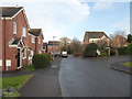
Treacle Nook, Lyppard-Woodgreen
Part of the huge complex of Warndon Villages. The photographer is stood on Millhams Avenue.
Image: © Chris Allen
Taken: 25 Oct 2021
0.01 miles
2
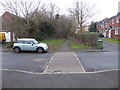
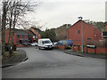
Path crossing Millhams Avenue, Lyppard-Woodgreen
I had not included a street name in this view and it took me quite a long time with the aerial view and Streetview to locate it.
Image: © Chris Allen
Taken: 24 Jan 2020
0.03 miles
3
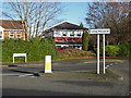
Plantation Drive, The Lyppards, worcester
A road in Warndon Villages through part of a large development with several subdivisions all prefixed with Lyppard. The Orbital Pedway crosses the road here.
Image: © Chris Allen
Taken: 25 Oct 2021
0.03 miles
4
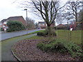
Race Field, Lyppard-Woodgreen
Seen from Millhams Avenue.
Image: © Chris Allen
Taken: 15 Dec 2019
0.05 miles
5
Debdale Avenue, Lyppard-Woodgreen
Debdale Avenue is the main spine road in Lyppard-Woodgreen but terminates in a T-shaped formation with both arms being cul-de-sacs. Lyppard-Woodgreen is a typical Warndon Village with a sinuous main road that ends in a cul-de-sac with further roads branching off that may interconnect within the village but do not provide vehicular access to any of the other villages. They do, however, interconnect on foot but it is very hit and miss. I spend quite a bit of time coming back down roads the same way I went up them. Also, when you cut through between villages you leave little bits to explore later.
Image: © Chris Allen
Taken: 15 Dec 2019
0.05 miles
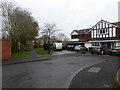
6
Millhams Avenue, Lyppard-Woodgreen
Race Field is seen leading off to the right in the background while Millhams Avenue curves to the left. The view is from Debdale Avenue. Most of my photographs of Warndon Villages are taken from the vicinity of road junctions.
Image: © Chris Allen
Taken: 15 Dec 2019
0.05 miles
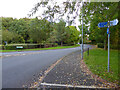
7
Marsh Avenue, Long Meadow
This is the turn off the roundabout on the B4638. Marsh Avenue is a sinuous cul-de-sac that forms the main spine road of Long Meadow.
Image: © Chris Allen
Taken: 1 Dec 2019
0.06 miles
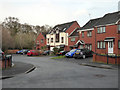
8
Play area on Debdale Avenue, Lyppard-Woodgreen
The road to the left is Little Piece. In the background and moving to the left is Windles Row while Debdale Avenue turns to the right.
Image: © Chris Allen
Taken: 24 Jan 2020
0.07 miles
9
Middleton Gardens, Long Meadow, Warndon Villages, Worcester
The blind end of this cul-de-sac with a foot path linking it to Marsh Avenue and cutting a corner on foot. Marsh Avenue is the spine road for Long Meadow with multiple cul-de-sacs branching off.
Image: © Chris Allen
Taken: 20 Feb 2021
0.07 miles
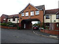
10
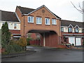
Lord's Heath, Lyppard-Woodgreen
This named street is through this archway off Debdale Avenue. Warndon Villages seem never-ending and the number of different meaningful views seems a fairly large number also, without resorting to individual houses, which I would think overly intrusive.
Image: © Chris Allen
Taken: 15 Dec 2019
0.08 miles