IMAGES TAKEN NEAR TO
Upper Welland Road, MALVERN, WR14 4LA
Introduction
This page details the photographs taken nearby to Upper Welland Road, WR14 4LA by members of the Geograph project.
The Geograph project started in 2005 with the aim of publishing, organising and preserving representative images for every square kilometre of Great Britain, Ireland and the Isle of Man.

There are currently over 7.5m images from over14,400 individuals and you can help contribute to the project by visiting https://www.geograph.org.uk
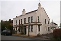
Image Map
Images are licensed for reuse under creativecommons.org/licenses/by-sa/2.0
Notes
- Clicking on the map will re-center to the selected point.
- The higher the marker number, the further away the image location is from the centre of the postcode.
Image Listing (271 Images Found)
Images are licensed for reuse under creativecommons.org/licenses/by-sa/2.0
Image
Details
Distance
1
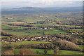
Upper Welland
Upper Welland viewed from on top of the Malvern Hills, beyond the Severn valley Bredon Hill can be seen, along with Dumbleton Hill and Aldterton Hill to the right with the Cotswold escarp as a backdrop.
Image: © Philip Halling
Taken: 18 Dec 2011
0.01 miles
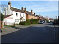
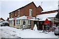
2
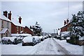
Upper Welland Road in the snow
Looking down through the village.
No snow ploughs or gritters have managed to get through today.
Image: © Bob Embleton
Taken: 6 Jan 2010
0.02 miles
3
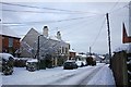
Upper Welland in the snow
The scene is dominated by the snow covered telephone lines radiating out from the post.
The large white building was the Hawthorns pub though it has now closed.
Image: © Bob Embleton
Taken: 6 Jan 2010
0.03 miles
4
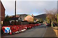
Gas Excavations in Upper Welland Road
Disruption and traffic lights as holes are dug outside each property to feed yellow plastic pipe up the old iron pipes to each house. In the distance are Black hill (left) and Pinnacle Hill (right). For a look down one of the holes see Image
Image: © Bob Embleton
Taken: 9 Dec 2007
0.03 miles
5
The Hawthorn Inn
Now closed. The only pub in the village of Upper Welland. Used to be a well renowned restaurant. Built, as were most of the houses in the village, on land that had been part of Lower Assart or Assarts Common. The common land was enclosed after the 1851 Welland Inclosure Act which stipulated how each new field boundary must be planted with hawthorn hedges. It is thought that that is how the Inn got its name.
Image: © Bob Embleton
Taken: 26 Apr 2008
0.03 miles
6
Houses in Upper Welland
Houses in Upper Welland on Upper Welland Road.
Image: © Philip Halling
Taken: 22 Mar 2021
0.03 miles
7
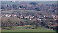
Upper Welland
Viewed from Broad Down on the Malvern Hills.
The village has developed from a triangular piece of common land known as Lower Assart before the Welland Inclosure Act of 1851 handed the land over to established land owners of Welland parish.
The common land started to have houses with large plots of land built on it. These have continuously been infilled over the last 160 years.
The rough land with many evergreen trees is the St Wulstan's Nature Reserve on the site of the hospital built for the expected D-Day casualties in the Second World War.
It later became a very successful rehabilitation mental hospital.
Shuttlefast Farm is near the top of the picture.
Image: © Bob Embleton
Taken: 16 Jan 2012
0.03 miles
8
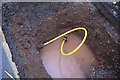
Gas Work in Upper Welland Road
The view down one of the holes (flooded by over 48 hours of December rain). Image A new plastic pipe is inserted into the old iron pipe. For the archaeologist, it is interesting to note how thin the road foundations are.
Image: © Bob Embleton
Taken: 9 Dec 2007
0.03 miles
9
Upper Welland village shop
In this weather the shop is a life saver.
Running a little short on many supplies,
but someone has made the snowman very proud.
Image: © Bob Embleton
Taken: 6 Jan 2010
0.04 miles
10
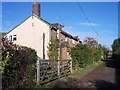
Watery Lane, Upper Welland
A 12 ft wide "Private Road or Carriage Way" as defined by the Welland Inclosure Act of 1851. still unmade and lit by gas lamps until a year or two ago.
Image: © Bob Embleton
Taken: 13 Nov 2005
0.04 miles