IMAGES TAKEN NEAR TO
Assarts Road, MALVERN, WR14 4HW
Introduction
This page details the photographs taken nearby to Assarts Road, WR14 4HW by members of the Geograph project.
The Geograph project started in 2005 with the aim of publishing, organising and preserving representative images for every square kilometre of Great Britain, Ireland and the Isle of Man.

There are currently over 7.5m images from over14,400 individuals and you can help contribute to the project by visiting https://www.geograph.org.uk
Image Map
Images are licensed for reuse under creativecommons.org/licenses/by-sa/2.0
Notes
- Clicking on the map will re-center to the selected point.
- The higher the marker number, the further away the image location is from the centre of the postcode.
Image Listing (90 Images Found)
Images are licensed for reuse under creativecommons.org/licenses/by-sa/2.0
Image
Details
Distance
1
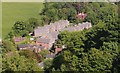
Homestead Close
Recent infill. The large older house in the trees near the top of the picture is called The Homestead. The grounds to the west have been developed with over a dozen houses (worth 3 million pounds or more!). Viewed from the path going around the eastern side of Black Hill.
Image: © Bob Embleton
Taken: 20 May 2007
0.02 miles
2
Homestead Close
A fairly new development cramming 14 or so detached houses in part of the garden of the Homestead.
Viewed from Black Hill.
Image: © Bob Embleton
Taken: 14 Oct 2012
0.02 miles
3
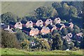
Assarts and Upper Welland
Viewed from the south end of Pinnacle Hill.
The now built up area nearest the hills is locally known as Assarts whilst the more distant built up area to the right hand side is Upper Welland.
The latter was known as Lower Assart in the pre inclosure years of the 1840s.
Assarting was the medieval practice of clearing the hunting forest of trees to create farm land under licence.
In 1196 the Bishop of Worcester was granted a licence to extend his assart at Welland Mill.
The creation of these two areas may date from as far back as then.
Image: © Bob Embleton
Taken: 16 Jan 2011
0.04 miles
4
Wells Close in the February Snow
Originally social housing (possibly owned by the Co-op) built around 1960 in the "field" above Heathlands Close off Assarts Road.
Image: © Bob Embleton
Taken: 10 Feb 2007
0.04 miles
5
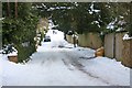
Snow covered Assarts Road
A very steep road equipped with a yellow grit box for those daring to venture.
Image: © Bob Embleton
Taken: 9 Jan 2010
0.05 miles
6
Homestead Close
A recent in-fill development squeezing 14 detached houses into the upper gardens of The Homestead.
Viewed from the bridleway to Hanley Swan.
Image: © Bob Embleton
Taken: 9 Jan 2010
0.06 miles
7
Homestead Close
A recent in-fill development on the steep gardens of The Homestead.
Viewed from Kings Road.
Image: © Bob Embleton
Taken: 9 Jan 2010
0.07 miles
8
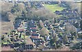
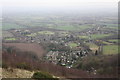
Assarts, Malvern Wells
The area gets its name, Assarts, from the medieval clearance of a section of the Chase (hunting ground) under licence.
On the 1841 Welland Tithe Map it is marked as Upper Assart Common.
A decade later the Welland Inclosure Act allowed the common land to be exploited and it has slowly been consumed by housing developments.
The Assarts playing field (top right) remains open for recreational use, though a corner has been fenced off for the Scout hut.
Above that (towards the camera) there are three post war developments:-
Heathlands Close, council houses,
Wells Close, built by the Co-op I'm told,
Woodlands Close, private detached built in the late 1970s.
On the left of the photo the recent Homestead Close has been built in what was the garden of the large house "Heathlands".
At the very bottom of the photo is the rather ornate Malvern Wells C of E primary school on the main A449 Wells Road.
Image: © Bob Embleton
Taken: 27 Jan 2013
0.08 miles
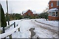
9
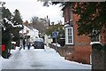
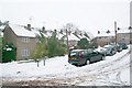
Snow covered Kings Road
At the junction with the very steep Assarts Road.
Image: © Bob Embleton
Taken: 9 Jan 2010
0.09 miles
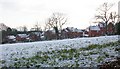
10
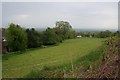
Horse pasture
Between the Upper Welland road (right) and the infill housing off Assarts road. currently used for horses, but how long before this green space is swamped by houses?
Image: © Bob Embleton
Taken: 4 May 2008
0.09 miles