IMAGES TAKEN NEAR TO
Brent Road, BRENTFORD, TW8 8BP
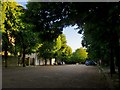
Introduction
This page details the photographs taken nearby to Brent Road, TW8 8BP by members of the Geograph project.
The Geograph project started in 2005 with the aim of publishing, organising and preserving representative images for every square kilometre of Great Britain, Ireland and the Isle of Man.

There are currently over 7.5m images from over14,400 individuals and you can help contribute to the project by visiting https://www.geograph.org.uk
Image Map
Images are licensed for reuse under creativecommons.org/licenses/by-sa/2.0
Notes
- Clicking on the map will re-center to the selected point.
- The higher the marker number, the further away the image location is from the centre of the postcode.
Image Listing (434 Images Found)
Images are licensed for reuse under creativecommons.org/licenses/by-sa/2.0
Image
Details
Distance
1
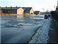
Canal at Brentford
This is the site of the Brentford Lock Development. Shot taken shortly before the clearing of the site when we used to have winters.
Image: © Alan Morrison
Taken: 3 Jan 2002
0.04 miles
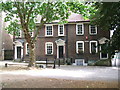
2
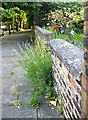
Front-garden wall, The Butts, Brentford
The garden wall belongs to a Georgian house toward the west end of The Butts. Where else in London could you find lavender growing in the street?
Image: © Stefan Czapski
Taken: 14 Jun 2014
0.05 miles
3
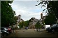
The Butts, Brentford, looking towards Upper Butts
Image: © john bristow
Taken: 18 Sep 2017
0.05 miles
4
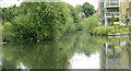
River Brent old channel
One of a number of stretches of the River Brent that were bypasses when it was canalised to become the Grand Union Canal. It includes a sluice weir (behind the new buildings) to regulate the flow in the canal.
Image: © Alan Murray-Rust
Taken: 23 Jul 2008
0.05 miles
5
The Butts, Brentford: view south-west
A most unexpected corner of west London - or, if you prefer, of old west Middlesex. From Half Acre, the Butts leads south-west, and goes nowhere in particular - linking to a couple of quiet residential streets and a passageway through to the Market Place.
Behind the wall seen on the left is St Mary's Convent; beyond that a little terrace of cottages that could be the oldest buildings to survive here - they look as if they could date from before 1700. The other side of the street is mostly Victorian http://www.geograph.org.uk/photo/4030145 At its western end, the Butts opens out into a square (of sorts) where the houses are mostly Georgian, built on ground that slopes away toward the River Brent and the canal.
Image: © Stefan Czapski
Taken: 14 Jun 2014
0.05 miles
6
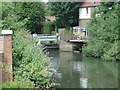
Sluice weir on the River Brent
This is the sluice weir controlling the main flow of water through Brentford Basin and the Gauging Locks.
Image: © Alan Murray-Rust
Taken: 23 Jul 2008
0.05 miles
7
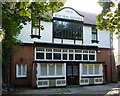
Former Boatmen's Institute, Brentford
The building backs on to the River Brent, and is approached on its landward side from the Butts. It is now a private residence.
For something of the history of the building, see: http://www.geograph.org.uk/photo/4030059
Image: © Stefan Czapski
Taken: 14 Jun 2014
0.05 miles
8
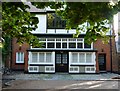
Former Boatmen's Institute, The Butts, Brentford: front entrance
The building is approached from The Butts on the landward side, and backs on to the River Brent. It is listed, Grade 2.
According to the listing:
'The Boatmen's Institute provided basic education including religious instruction to the children of boatmen and two rooms of the living accommodation above were used as maternity provision for boatmen's wives until the National Health Service was set up. Only 5 or 6 examples of boatmen's institutes are thought to exist nationally'.
The architectural style is very reminiscent of Bedford Park, not so far away: http://www.geograph.org.uk/photo/2432496 The architect in this instance is said to have been Noel Parr, but it is clear that he was much influenced by Norman Shaw.
For a more complete view of the façade see: http://www.geograph.org.uk/photo/4029902
The full listing is here: http://www.imagesofengland.org.uk/Details/default.aspx?pid=2&id=480166
Image: © Stefan Czapski
Taken: 14 Jun 2014
0.05 miles
9
The Butts, Brentford
Georgian houses on the Butts estate in Brentford.
Image: © Graham Newell
Taken: 29 Jul 2008
0.06 miles
10
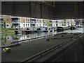
Brentford Basin
Seen from under the canopy of one of the remaining canalside warehouses here. The narrowboat in the foreground is berthed where boats and barges would be loaded and unloaded.
Image: © Alan Murray-Rust
Taken: 23 Jul 2008
0.06 miles