IMAGES TAKEN NEAR TO
Hanworth Air Park, FELTHAM, TW13 7EY
Introduction
This page details the photographs taken nearby to Hanworth Air Park, TW13 7EY by members of the Geograph project.
The Geograph project started in 2005 with the aim of publishing, organising and preserving representative images for every square kilometre of Great Britain, Ireland and the Isle of Man.

There are currently over 7.5m images from over14,400 individuals and you can help contribute to the project by visiting https://www.geograph.org.uk
Image Map
Images are licensed for reuse under creativecommons.org/licenses/by-sa/2.0
Notes
- Clicking on the map will re-center to the selected point.
- The higher the marker number, the further away the image location is from the centre of the postcode.
Image Listing (25 Images Found)
Images are licensed for reuse under creativecommons.org/licenses/by-sa/2.0
Image
Details
Distance
1
Hanworth Park House
The house is vast, but screened from view by unmanaged woodland, and thus far there appears to be just one photo of it here on Geograph: http://www.geograph.org.uk/photo/62809
I searched for some while, but was unable to get a more open view than this - having found (I suspect) the same gap that steve found, on the south-west side of the house. The main façade is illustrated in the Middlesex volume of Pevsner's 'The Buildings of England' - two storeys above a basement, with a central Doric portico approached by two flights of steps. Verandahs with wrought-iron screens run almost the full length of the building, supported on cast-iron columns. Even in the depth of winter I was unable to get a glimpse of the façade, but suspect it faces south-east - built to command a wide prospect of the park.
Ian Yarham (always conscientious in his research) has contributed a pretty comprehensive history of the site: http://www.geograph.org.uk/photo/2886796 but it seems that his April visit yielded no satisfactory image of the house itself.
Plans exist to refurbish the house - to be used as a hotel - but whether these will proceed in the present economic climate remains to be seen.
Image: © Stefan Czapski
Taken: 4 Jan 2014
0.02 miles
2
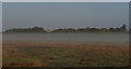
Hanworth Park on a misty morning
Hanworth Park House can be seen beyond the trees.
Image: © habiloid
Taken: 23 Oct 2016
0.03 miles
3
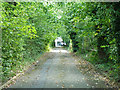
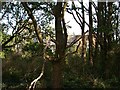
Drive to Hanworth Park House
A notable building at the end, but more or less disused it seems.
Image: © Robin Webster
Taken: 14 Sep 2012
0.03 miles
4
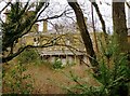
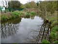
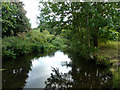
Longford River
This much culverted river, formerly known as Queen's or Cardinal's River, is exposed here to act as a partial moat around one side of the disused Hanworth Park House. A series of straights and right angled bends indicate the natural look was not in vogue when the grounds were laid out.
Image: © Robin Webster
Taken: 14 Sep 2012
0.05 miles
5
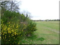
Hanworth Park
Hanworth Park House was built between 1802 and 1835 as a replacement for the manor house that had served as a hunting lodge for, among others, Henry VII, Henry VIII and Queen Elizabeth I. It was used as a military hospital during the First World War, as a flying club between the wars, a hotel from 1936 to 1953 and an old people's home from 1953 to 1992 when it closed. Hanworth Park House is now fenced off and semi-derelict. The park was used as a grass airfield between 1917 and 1919, and 1929 and 1947. In the 1930s, it was best known as a centre for private flying, society events, visits by the Graf Zeppelin airship, and for aircraft manufacture by General Aircraft Limited (GAL) 1934-1949. In 1946, Heathrow came into use as the principal London Airport, and for several years flights at Hanworth were subject to Heathrow air traffic clearance, eventually growing to delays of several hours so that no fixed-wing flights were recorded after 1955.
In 1956, Feltham Urban District Council purchased Hanworth Park. The Longford River was partly culverted and covered to permit aircraft to taxi over it. In this photograph Hanworth Park House lies beyond the vegetation to the left, whilst the Longford River passes beneath the grass ahead.
Image: © Marathon
Taken: 4 Apr 2012
0.08 miles
6
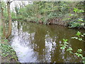
The Longford River entering Hanworth Park
The Longford River was constructed in 1638 to take water from the River Colne. This would then supplement the water supply to Hampton Court and enable the development of the water features in the park. Here after passing through Feltham the Longford River enters Hanworth Park. Shortly it goes underground under much of the park before re-emerging to pass under the A314. Surprisingly the river was put underground to allow aircraft to take off and land - see http://www.geograph.org.uk/photo/2886196
Image: © Marathon
Taken: 4 Apr 2012
0.08 miles
7
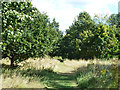
Path, Hanworth Park
Formerly on the estate of Hanworth Park House, then an airfield (when the Longford River was culverted under it), then public open space.
Image: © Robin Webster
Taken: 14 Sep 2012
0.08 miles
8
The Longford River in Hanworth Park
The Longford River was constructed in 1638 to take water from the River Colne. This would then supplement the water supply to Hampton Court and enable the development of the water features in the park. Here after passing through Feltham, the Longford River runs through the northern part of Hanworth Park before going underground to re-emerge and pass under the A314. Surprisingly the river was put underground to allow aircraft to take off and land - see http://www.geograph.org.uk/photo/2886196
Image: © Marathon
Taken: 4 Apr 2012
0.09 miles
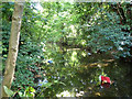
9
Longford River
Just after it has emerged from a culverted section under a business estate.
Image: © Robin Webster
Taken: 14 Sep 2012
0.11 miles
10
Hanworth Park House
This is in Hanworth Park but surrounded by fences and is very overgrown. It seems to be deserted at the moment.
Image: © steve
Taken: 9 Oct 2005
0.12 miles