IMAGES TAKEN NEAR TO
Queenswood Avenue, HAMPTON, TW12 3AT
Introduction
This page details the photographs taken nearby to Queenswood Avenue, TW12 3AT by members of the Geograph project.
The Geograph project started in 2005 with the aim of publishing, organising and preserving representative images for every square kilometre of Great Britain, Ireland and the Isle of Man.

There are currently over 7.5m images from over14,400 individuals and you can help contribute to the project by visiting https://www.geograph.org.uk
Image Map
Images are licensed for reuse under creativecommons.org/licenses/by-sa/2.0
Notes
- Clicking on the map will re-center to the selected point.
- The higher the marker number, the further away the image location is from the centre of the postcode.
Image Listing (43 Images Found)
Images are licensed for reuse under creativecommons.org/licenses/by-sa/2.0
Image
Details
Distance
1
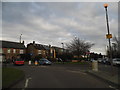
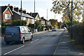
Hanworth Road at the junction of Uxbridge Road
Image: © David Howard
Taken: 14 Apr 2013
0.09 miles
2
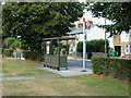
Hanworth Road bus stop, on Uxbridge Road
For buses towards Feltham. The only service appears to be route 285.
Image: © Robin Webster
Taken: 16 Sep 2012
0.10 miles
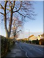
4
Wide verge, Uxbridge Road
A multitude of wooden posts have been placed lest any vehicle ventures onto the verge via the crossing driveways.
Image: © Robin Webster
Taken: 16 Sep 2012
0.11 miles
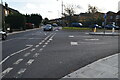
6
Uxbridge Road, Hampton (1)
View NNW from near the junction with Hanworth Road.
The name itself is interesting - this was the main road to Uxbridge in days when west Middlesex was still largely rural - and Uxbridge the next place of any consequence as you headed north-west. These days much of the intervening terrain is residential suburbs, and a stretch of the old road that crossed the Heathrow site (at its eastern end) has disappeared.
Image: © Stefan Czapski
Taken: 1 Dec 2013
0.12 miles
7
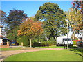
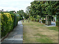
Roy Grove Hampton
In the centre of the photo is the cannon marking the south eastern end of the original OS base line Image
Image: © Rod Allday
Taken: 15 Oct 2011
0.12 miles
9
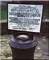
General Roy monument, Hampton Hill.
This is a very significant picture for the Geograph Project. The cannon was erected in 1926 to commemorate the 200th anniversary of Major General William Roy, who conceived the idea of using triangulation to produce a map of the whole country, thus laying the foundations for the Ordnance Survey.
The monument was placed at the south-eastern end of the very first base-line for the Ordnance Survey, which was at the time part of Hounslow Heath. The other end is marked by a similar monument on the north side of Heathrow Airport (which has been rendered rather pointless by it having been moved to allow development there).
The area was chosen because at the time it was flat and unobstructed, allowing a long, straight baseline to be measured. This was done using accurately measured rods which were used almost like a huge pair of rulers to measure the length of the line. Modern surveys have shown that this was just a couple of inches out - a remarkable achievement.
The cannon is today on the corner of a fairly ordinary pre-war housing estate, but the significance is also recalled in the street names - Cannon Close and Roy Grove.
Image: © Stephen Williams
Taken: 27 Dec 1990
0.12 miles
10
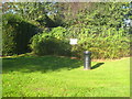
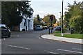
Where it all began!
This cannon embedded in the ground in Roy Grove marks the south eastern end of General Roy's original base line for setting out the Ordnance Survey triangulation of Great Britain in 1784. The white plaque in the background was put in place in 1926 to mark the 200th anniversary of General Roy's birth. The north western end of the base line is at Heathrow, on the other side of what was at the time Hounslow Heath Image
Image: © Rod Allday
Taken: 15 Oct 2011
0.12 miles