General Roy monument, Hampton Hill.
Introduction
The photograph on this page of General Roy monument, Hampton Hill. by Stephen Williams as part of the Geograph project.
The Geograph project started in 2005 with the aim of publishing, organising and preserving representative images for every square kilometre of Great Britain, Ireland and the Isle of Man.

There are currently over 7.5m images from over 14,400 individuals and you can help contribute to the project by visiting https://www.geograph.org.uk
General Roy monument, Hampton Hill.
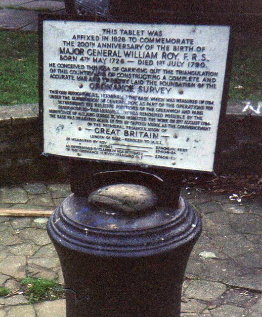
Image: © Stephen Williams Taken: 27 Dec 1990
This is a very significant picture for the Geograph Project. The cannon was erected in 1926 to commemorate the 200th anniversary of Major General William Roy, who conceived the idea of using triangulation to produce a map of the whole country, thus laying the foundations for the Ordnance Survey. The monument was placed at the south-eastern end of the very first base-line for the Ordnance Survey, which was at the time part of Hounslow Heath. The other end is marked by a similar monument on the north side of Heathrow Airport (which has been rendered rather pointless by it having been moved to allow development there). The area was chosen because at the time it was flat and unobstructed, allowing a long, straight baseline to be measured. This was done using accurately measured rods which were used almost like a huge pair of rulers to measure the length of the line. Modern surveys have shown that this was just a couple of inches out - a remarkable achievement. The cannon is today on the corner of a fairly ordinary pre-war housing estate, but the significance is also recalled in the street names - Cannon Close and Roy Grove.
Images are licensed for reuse under creativecommons.org/licenses/by-sa/2.0
Image Location
Latitude
51.42633
Longitude
-0.365133