IMAGES TAKEN NEAR TO
Polcrebo Downs, Crowan, CAMBORNE, TR14 9NJ
Introduction
This page details the photographs taken nearby to Polcrebo Downs, Crowan, TR14 9NJ by members of the Geograph project.
The Geograph project started in 2005 with the aim of publishing, organising and preserving representative images for every square kilometre of Great Britain, Ireland and the Isle of Man.

There are currently over 7.5m images from over14,400 individuals and you can help contribute to the project by visiting https://www.geograph.org.uk
Image Map
Images are licensed for reuse under creativecommons.org/licenses/by-sa/2.0
Notes
- Clicking on the map will re-center to the selected point.
- The higher the marker number, the further away the image location is from the centre of the postcode.
Image Listing (6 Images Found)
Images are licensed for reuse under creativecommons.org/licenses/by-sa/2.0
Image
Details
Distance
1
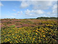
Purple & Yellow flowers brighten up a September morning
Gorse & heather blooms on Polcrebo Downs.
Image: © Matthew Hatton
Taken: 21 Sep 2018
0.10 miles
2
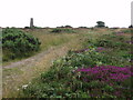
Polcrebo Downs
Chimney of old mine, probably Crowan and Wendron mine (also known as Wheal Releath).
Image: © Sheila Russell
Taken: 5 Jul 2006
0.14 miles
3
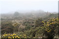
Heathland on Polcrebo Downs
Rough ground sustaining only gorse and heather and a few grasses, probably due to the poor soil in this former mining area. Seen on a very misty March afternoon.
Image: © Rod Allday
Taken: 30 Mar 2011
0.18 miles
4
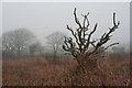
Dead tree on Polcrebo Downs
This rough heathland area of poor soil has possibly arisen as a result of the nearby historic mining activity.
Image: © Rod Allday
Taken: 30 Mar 2011
0.19 miles
5
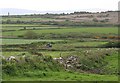
Farmland and Heathland
The heathland in the distance at the western edge of this square marks an old mining area. Most of the rest of the square is pasture land.
Image: © Tony Atkin
Taken: 20 May 2006
0.24 miles
6
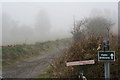
Public bridleway on Polcrebo Downs
Leading to Heatherbell.
Image: © Rod Allday
Taken: 30 Mar 2011
0.25 miles