IMAGES TAKEN NEAR TO
Blackawton, TOTNES, TQ9 7BJ
Introduction
This page details the photographs taken nearby to TQ9 7BJ by members of the Geograph project.
The Geograph project started in 2005 with the aim of publishing, organising and preserving representative images for every square kilometre of Great Britain, Ireland and the Isle of Man.

There are currently over 7.5m images from over14,400 individuals and you can help contribute to the project by visiting https://www.geograph.org.uk
Image Map (Loading...)


Getting Data...Please wait
Leaflet Map data © OpenStreetMap
Images are licensed for reuse under creativecommons.org/licenses/by-sa/2.0
Notes
- Clicking on the map will re-center to the selected point.
- The higher the marker number, the further away the image location is from the centre of the postcode.
Image Listing (113 Images Found)
Images are licensed for reuse under creativecommons.org/licenses/by-sa/2.0
Image
Details
Distance
1
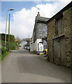
Uphill and northeast out of Blackawton
The slate-hung house is Horseshoe Cottage.
Image: © Robin Stott
Taken: 3 Apr 2017
0.01 miles

3
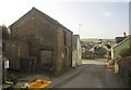
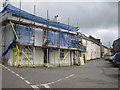
Hillside terrace, Blackawton
Taken mainly to show a redundant barn, on the left, before it is converted into accommodation; a planning application is attached to the building. It can also just be seen in Image Two doors away down Main Street is the Normandy Arms, straddling a northing gridline - see http://www.geograph.org.uk/search.php?i=39475483 . I think the various roadwork barriers have been flattened by strong wind.
Image: © Derek Harper
Taken: 30 Jan 2013
0.02 miles
4
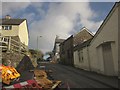
Main Street, Blackawton
A reverse view of Image], showing the barn whose appearance will be altered. In the foreground are roadworks barriers, some being stored, others that seem to have collapsed in strong winds.
Image: © Derek Harper
Taken: 30 Jan 2013
0.02 miles
5
Houses in Blackawton
On the road above Normandy Cross leading to Trenchfirs Corner, and also seen in Image and Image NCN28 goes this way.
Image: © Derek Harper
Taken: 30 Aug 2022
0.02 miles

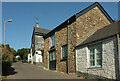
7

Blackawton: Normandy Arms
Closed on Monday lunchtimes. By the turning to Strete: Chapel Street.
Normandy Arms and Forces Tavern, to the north of the village, were both re-named, presumably, in recognition of the wartime army in the area in 1944
Image: © Martin Bodman
Taken: 18 Apr 2011
0.02 miles
8
Former pub and a view east along Chapel Street, Blackawton
This was last photographed for Geograph in 2012 as The Normandy Arms: Image TripAdvisor has reviews from 2016 while CAMRA reports the pub closed. This looks very like another conversion to residential use. The village has another pub, The George Inn: Image
Image: © Robin Stott
Taken: 3 Apr 2017
0.02 miles
9
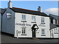
Normandy Arms Blackawton
Former pub up for sale in 2006. It did reopen as a pub but has closed down again in the last couple of years, I believe.
Image: © Brian Whittle
Taken: 9 Feb 2006
0.02 miles
10
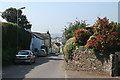
Blackawton: Main Street
View towards the centre of the village, by the entrance to 'Hillcrest'
Image: © Martin Bodman
Taken: 18 Apr 2011
0.02 miles