IMAGES TAKEN NEAR TO
Warfleet Creek Road, DARTMOUTH, TQ6 9GJ
Introduction
This page details the photographs taken nearby to Warfleet Creek Road, TQ6 9GJ by members of the Geograph project.
The Geograph project started in 2005 with the aim of publishing, organising and preserving representative images for every square kilometre of Great Britain, Ireland and the Isle of Man.

There are currently over 7.5m images from over14,400 individuals and you can help contribute to the project by visiting https://www.geograph.org.uk
Image Map
Images are licensed for reuse under creativecommons.org/licenses/by-sa/2.0
Notes
- Clicking on the map will re-center to the selected point.
- The higher the marker number, the further away the image location is from the centre of the postcode.
Image Listing (88 Images Found)
Images are licensed for reuse under creativecommons.org/licenses/by-sa/2.0
Image
Details
Distance
1
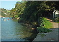
Warfleet Creek
From Dartmouth Footpath 13 (right), looking along the southern side of the creek.
Image: © Derek Harper
Taken: 13 Sep 2020
0.01 miles
2
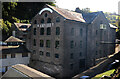
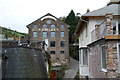
Former brewery, Warfleet
This industrial building was built in 1819 as a brewery, later became Dartmouth Pottery and is now accommodation following conversion. This view was rather spoilt by being against the light. It is Listed Grade II.
Image: © Chris Allen
Taken: 11 Oct 2022
0.01 miles
3
Former brewery, Warfleet
This industrial building was built in 1819 as a brewery, later became Dartmouth Pottery and is now accommodation following conversion. It is Listed Grade II.
Image: © Chris Allen
Taken: 11 Oct 2022
0.01 miles
4
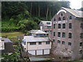
Former Dartmouth Pottery
All the images so far of this building at Warfleet seem to show the other end. Built as a brewery, later a pottery, and now divided into 9 flats and called "The Pottery". "Dated 1819 ... Both end walls in the same style; 1:2:1-window ranges divided by giant pilasters to round arches and top windows with round-headed arches. Because of the slope, the ground-floor level is buried at the uphill end" https://www.historicengland.org.uk/listing/the-list/list-entry/1197637 .
Image: © Derek Harper
Taken: 26 Mar 2017
0.01 miles
5
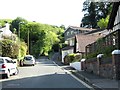
Seen between the houses Warfleet Pottery
From Castle Road. Not sure if the pottery is still working.
Image: © jeff collins
Taken: 2 Dec 2013
0.01 miles
6

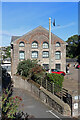
Ordnance Survey Flush Bracket (G5072)
This OS Flush Bracket can be found on the Old Dartmouth Pottery Building. It marks a point 11.385m above mean sea level.
Image: © Adrian Dust
Taken: 28 Mar 2019
0.02 miles
7
Ex Dartmouth Pottery, now apartments at Warfleet
Image: © Rob Purvis
Taken: 19 Aug 2012
0.02 miles
9
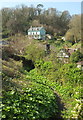
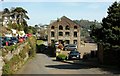
Path to Warfleet
A permissive path dropping from woodland below Gallants Bower to meet Weeke Hill. The prominent hillside house with verandah is Woodlands. "According to the owners, Woodlands was built for the manager of Warfleet Brewery, now the Dartmouth Pottery" https://www.historicengland.org.uk/listing/the-list/list-entry/1218363 - and now flats - see Image
Image: © Derek Harper
Taken: 26 Mar 2017
0.03 miles
10
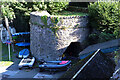
Disused lime kiln, Warfleet
The kiln and associated quay are Listed Grade II. The kiln is probably early to mid-19th century and built from local stone rubble.
Image: © Chris Allen
Taken: 11 Oct 2022
0.04 miles