IMAGES TAKEN NEAR TO
Crudgington, TELFORD, TF6 6HS
Introduction
This page details the photographs taken nearby to TF6 6HS by members of the Geograph project.
The Geograph project started in 2005 with the aim of publishing, organising and preserving representative images for every square kilometre of Great Britain, Ireland and the Isle of Man.

There are currently over 7.5m images from over14,400 individuals and you can help contribute to the project by visiting https://www.geograph.org.uk
Image Map
Images are licensed for reuse under creativecommons.org/licenses/by-sa/2.0
Notes
- Clicking on the map will re-center to the selected point.
- The higher the marker number, the further away the image location is from the centre of the postcode.
Image Listing (33 Images Found)
Images are licensed for reuse under creativecommons.org/licenses/by-sa/2.0
Image
Details
Distance
1
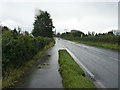
A damp afternoon on the A442
Roughly halfway between Crudgington and Sleap. Passing traffic was throwing rainwater into the air.
Image: © Richard Law
Taken: 5 Nov 2017
0.02 miles
2
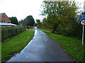
Private road in Crudgington
The current map shows this as a 'yellow' road, but if the signage is to be believed, it appears to have been disowned by the Highways Authority and passed to the residents of southern Crudgington as a private road. It's drivable, but has several speed bumps across it.
Image: © Richard Law
Taken: 5 Nov 2017
0.06 miles
3
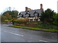
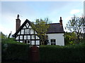
1, Waters Upton
A very short address for an important property. It's originally a late 17th or early 18th century timber-framed cottage, given a Grade II listing https://www.britishlistedbuildings.co.uk/101038599-1-waters-upton#.WhMzztSLTGg in 1983.
Image: © Richard Law
Taken: 5 Nov 2017
0.09 miles
5
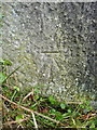
OS benchmark - Crudgington, gatepost east side of A442
An OS cutmark on a stone gatepost just to the SE of the Crudgington crossroads. It was levelled at 58.228m above Ordnance Datum Newlyn in 1958.
Image: © Richard Law
Taken: 5 Nov 2017
0.13 miles
6
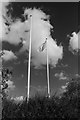
Dairy Crest flag at Crudgington
The Dairy Crest flag - probably the very same one which flew when I worked here nearly twenty years ago - still flies from the flagpole which stands in front of where the canteen and offices used to be. It's looking a bit the worse for wear here! Taken with a Pentax K1000 with a red filter on the lens, hence the dark sky.
Image: © John Winder
Taken: 27 Sep 2015
0.15 miles
7
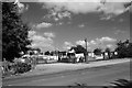
Security hut at Dairy Crest, Crudgington
This was the only part of the site still being used for its original purpose when I visited! The last stages of demolition were just being completed, prior to the site being redeveloped as housing. Once upon a time, the Dairy Crest plant was a landmark for miles around: having worked here, and commuted by bicycle from Wolverhampton, 23 miles away, I was more familiar with the view of the place from across the fields than most, and it came as a bit of a shock to drive towards the site and not be able to see it. In the background was once the canteen and office block and the "Special Products" division, where things like brandy butter were made at Christmas time.
Image: © John Winder
Taken: 27 Sep 2015
0.15 miles
8
The Lilacs, Crudgington
Grade II listed https://www.britishlistedbuildings.co.uk/101038602-the-lilacs-waters-upton#.WhM4w9SLTGg in 1983, The Lilacs is described as a 16th or 17th century, timber-framed cottage, with whitened brick infill panels. The wing to the right is a later (probably 19th century) extension.
Image: © Richard Law
Taken: 5 Nov 2017
0.15 miles
10
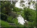
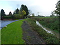
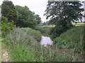
River Strine.
The river strine,at Crudgington.
Image: © Paul Beaman
Taken: 28 May 2007
0.16 miles