IMAGES TAKEN NEAR TO
Jackson Drive, TELFORD, TF4 3GS
Introduction
This page details the photographs taken nearby to Jackson Drive, TF4 3GS by members of the Geograph project.
The Geograph project started in 2005 with the aim of publishing, organising and preserving representative images for every square kilometre of Great Britain, Ireland and the Isle of Man.

There are currently over 7.5m images from over14,400 individuals and you can help contribute to the project by visiting https://www.geograph.org.uk
Image Map (Loading...)


Getting Data...Please wait
Leaflet Map data © OpenStreetMap
Images are licensed for reuse under creativecommons.org/licenses/by-sa/2.0
Notes
- Clicking on the map will re-center to the selected point.
- The higher the marker number, the further away the image location is from the centre of the postcode.
Image Listing (10 Images Found)
Images are licensed for reuse under creativecommons.org/licenses/by-sa/2.0
Image
Details
Distance
3
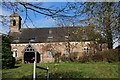
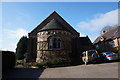
Former St Luke's Church, Doseley
Taken from St Luke's Road.
Image: © Ian S
Taken: 31 Mar 2016
0.17 miles
4
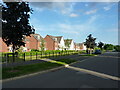
South along Cullis Drive, Lightmoor Village
New housing developments built in the last few years as part of the extensive Lightmoor Village estate between Horsehay and Doseley.
Image: © Richard Law
Taken: 16 Jun 2021
0.18 miles
6

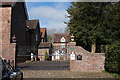
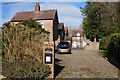
Former St Luke's Church, Doseley
When I took this photograph I didn't known that I was on private property, there were no signs to say it was no longer an active church. It is now a private dwelling.
Image: © Ian S
Taken: 31 Mar 2016
0.18 miles
7
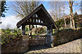
Former St Luke's Church, Doseley
Now a private dwelling.
Image: © Ian S
Taken: 31 Mar 2016
0.18 miles
10
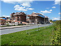
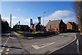
Housing development - Lightmoor
Telford's development continues apace. In this case, it's the building of a 'community village', sponsored by the Bournville Village Trust, which aims to create a community in the Lightmoor area with a 'village feel' to it. A new school is being built at the same time as the housing, along with open spaces, wooded areas, and small pools.
Image: © Richard Law
Taken: 9 May 2010
0.24 miles