IMAGES TAKEN NEAR TO
Cherrington Way, SHIFNAL, TF11 9QJ
Introduction
This page details the photographs taken nearby to Cherrington Way, TF11 9QJ by members of the Geograph project.
The Geograph project started in 2005 with the aim of publishing, organising and preserving representative images for every square kilometre of Great Britain, Ireland and the Isle of Man.

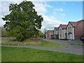
There are currently over 7.5m images from over14,400 individuals and you can help contribute to the project by visiting https://www.geograph.org.uk
Image Map
Images are licensed for reuse under creativecommons.org/licenses/by-sa/2.0
Notes
- Clicking on the map will re-center to the selected point.
- The higher the marker number, the further away the image location is from the centre of the postcode.
Image Listing (45 Images Found)
Images are licensed for reuse under creativecommons.org/licenses/by-sa/2.0
Image
Details
Distance
1
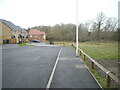
New houses at the end of Cherrington Way
Part of the extensive and quite recent Scarlett Oaks development on the outskirts of Shifnal.
Image: © Richard Law
Taken: 3 Dec 2021
0.01 miles
2
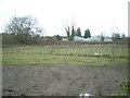
Undeveloped land at the end of Cherrington Way
This scene lies just to the right of Image, and shows an area of land left without houses as a kind of buffer-zone between the extensive Scarlett Oaks estate, and the railway line. The buildings visible beyond that are part of the Lamledge Lane industrial estate.
Image: © Richard Law
Taken: 3 Dec 2021
0.04 miles
3
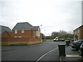
New houses on Owen Drive
Part of the extensive and quite recent Scarlett Oaks development on the outskirts of Shifnal.
Image: © Richard Law
Taken: 3 Dec 2021
0.06 miles
4
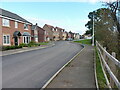
Looking southeast along Stone Drive
Stone Drive holds part of the new Scarlett Oaks housing estate, whilst the righthand side of the road still retains one of the old hedges that defined the former fields here.
Image: © Richard Law
Taken: 3 Nov 2021
0.07 miles
5
Houses between Stone Drive and Drabble Close
These houses have the railway line on an embankment just beyond them, but they do look out onto an old oak tree and a reasonable open grassy area.
Image: © Richard Law
Taken: 3 Nov 2021
0.08 miles
6
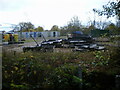
Construction company yard
The storage yard of JN Bentley just on the outskirts of Shifnal, with various mobile site and office accommodation units and an assortment of miscellaneous equipment in stock.
Image: © Richard Law
Taken: 24 Nov 2021
0.10 miles
7
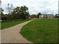
Pathway across an open area
With the remains of the former field boundary in place just to its northwest, this pathway leads across an open grassy area in the middle of the Scarlett Oaks housing estate.
Image: © Richard Law
Taken: 3 Nov 2021
0.11 miles
8
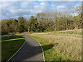
Pathway north of Stone Drive
Part of the path network that's been built to provide walks between all the houses in the new estates here on the southeast side of Shifnal. The railway line runs along the wooded embankment in the background.
Image: © Richard Law
Taken: 3 Nov 2021
0.11 miles
9
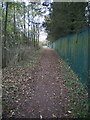
The Butts path
Marked on older maps as Lawton Lane, at which time it ran across open fields between Lamledge Lane at the eastern end and the Smithfield cattle market area on the western outskirts of Shifnal. The fields are now all covered in housing.
Image: © Richard Law
Taken: 24 Nov 2021
0.11 miles
10
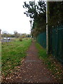
East along The Butts path
Looking out of Shifnal along The Butts (formerly Lawton Lane) towards its junction with Lamledge Lane in the bushes about 100 yards away.
Image: © Richard Law
Taken: 23 Nov 2021
0.12 miles