IMAGES TAKEN NEAR TO
Pitchcroft Lane, NEWPORT, TF10 9AU
Introduction
This page details the photographs taken nearby to Pitchcroft Lane, TF10 9AU by members of the Geograph project.
The Geograph project started in 2005 with the aim of publishing, organising and preserving representative images for every square kilometre of Great Britain, Ireland and the Isle of Man.

There are currently over 7.5m images from over14,400 individuals and you can help contribute to the project by visiting https://www.geograph.org.uk
Image Map
Images are licensed for reuse under creativecommons.org/licenses/by-sa/2.0
Notes
- Clicking on the map will re-center to the selected point.
- The higher the marker number, the further away the image location is from the centre of the postcode.
Image Listing (12 Images Found)
Images are licensed for reuse under creativecommons.org/licenses/by-sa/2.0
Image
Details
Distance
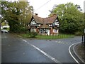
1
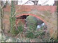
Bridge over Donnington Wood canal
This Bridge was built in the 1760's. It carries Pitchcroft lane over the Donnington Wood canal.
Image: © Roger Dean
Taken: 18 Feb 2007
0.04 miles
2
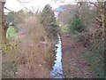
Donnington Wood Canal
This watercourse was once the Donnington Wood canal. It was the first canal to be built in Shropshire. Built between 1765 and 1767, it ran from the mines and iron works of Donnington Wood to the terminus at Pave Lane. The terminus was on the main route from Liverpool to London, now the A41.
Image: © Roger Dean
Taken: 18 Feb 2007
0.04 miles
3
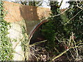
A bridge over the Donnington Wood Canal
The bridge from which Image was taken. It's one of the few remaining visible signs of the former Donnington Wood Canal, which was built in the 1760s to carry coal from mines at Donnington Wood to a road-side wharf near here at Pave Lane. Most of the main canal has succumbed to agricultural changes or subsequent landscaping and industrial developments, but a number of other branches of the canal are more evident, particularly around Lilleshall Image
A good description of the canal's construction, usage and history http://en.wikipedia.org/wiki/Donnington_Wood_Canal
Image: © Richard Law
Taken: 4 Apr 2013
0.06 miles
4
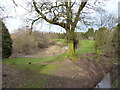
Donnington Wood canal and a pool
One of the few places where there's much visible remnant of the Donnington Wood canal - the water course in the bottom right of this shot. It was built to carry coal from the mines at Donnington Wood to a roadside wharf at Pave Lane. The large pool to the left is rapidly infilling with reeds and other vegetation.
Image: © Richard Law
Taken: 4 Apr 2013
0.07 miles
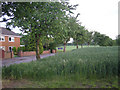
5

Stream viewed from a bridge high above
The stream is flooded and brown.
Image: © Jeremy Bolwell
Taken: 1 Nov 2023
0.09 miles
6
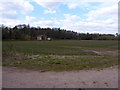
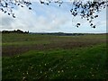
Across fields to The Homestead
An isolated house beside the woods leading to Lilleshall Hall.
Image: © Richard Law
Taken: 4 Apr 2013
0.13 miles
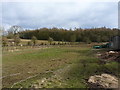
10
Distant view towards Lilleshal Hill and The Wrekin
Over the roofs of the poultry farm.
Image: © Jeremy Bolwell
Taken: 1 Nov 2023
0.21 miles