IMAGES TAKEN NEAR TO
Chetwynd End, NEWPORT, TF10 7JE
Introduction
This page details the photographs taken nearby to Chetwynd End, TF10 7JE by members of the Geograph project.
The Geograph project started in 2005 with the aim of publishing, organising and preserving representative images for every square kilometre of Great Britain, Ireland and the Isle of Man.

There are currently over 7.5m images from over14,400 individuals and you can help contribute to the project by visiting https://www.geograph.org.uk
Image Map
Images are licensed for reuse under creativecommons.org/licenses/by-sa/2.0
Notes
- Clicking on the map will re-center to the selected point.
- The higher the marker number, the further away the image location is from the centre of the postcode.
Image Listing (127 Images Found)
Images are licensed for reuse under creativecommons.org/licenses/by-sa/2.0
Image
Details
Distance
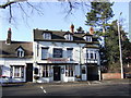
1
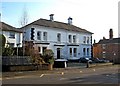
Bank House, Chetwynd End
An attractive building which is now a residential care home.
Image: © P L Chadwick
Taken: 6 Feb 2010
0.01 miles
2
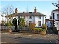
Old house, Chetwynd End
Another attractive old house in Chetwynd End, opposite the start of Green Lane. It is probably part of the neighbouring school. There is an interesting arch connecting this property and the adjoining property, Bank House.
Image
Image: © P L Chadwick
Taken: 6 Feb 2010
0.02 miles
4
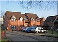
Brook House, Chetwynd End
This property offers 16 flats (1 bed & 2 bed) and is managed by the Beth Johnson Housing Association. It is unsupported accommodation. The house was built in 1987 and presumably takes its name after the small brook, which is adjacent to one side of the building. As the restored stretch of the Newport Canal is on the other side of the brook, some residents would have a nice view of the canal.
Image
Image: © P L Chadwick
Taken: 6 Feb 2010
0.04 miles
5
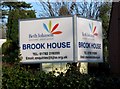
Brook House sign, Chetwynd End
This large sign is placed outside Brook House, so no-one can be unaware that this is a Beth Johnson Housing Association property.
Image
Image: © P L Chadwick
Taken: 6 Feb 2010
0.04 miles
6
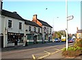
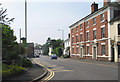
Kings Head, Chetwynd End
Another of Newport's many pubs. Next door is the appropriately named Fire Place.
The pub's sign:- Image
Image: © P L Chadwick
Taken: 6 Feb 2010
0.05 miles
7
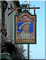
Kings Head pub sign, Chetwynd End
The King appears to be Henry VIII, but whether the pub dates back to that time is probably unlikely. At first glance, it can look as if Henry is wearing glasses, but this seems to be due to a layer of paint wearing off in places. The sign has probably been repainted many times over the years, but currently it is looking quite faded.
Image
Image: © P L Chadwick
Taken: 6 Feb 2010
0.05 miles
8
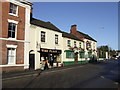
The Kings Head, Newport, Salop
A Marstons pub so you can't go wrong with the beer and if Pedigree is not your tipple then guest beers are available.
Image: © al partington
Taken: 6 Feb 2008
0.05 miles
9
The Bridge Inn, Newport, Salop
Recently restored but still a splendid Inn with a tempting range of real beers. Its namesake is still there but the Shrewsbury and Newport canal that it crossed has long since gone - but there are rumours and the Bridge might once again become a watering hole for narrow boaters.
Image: © al partington
Taken: 6 Feb 2008
0.06 miles
10
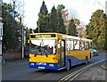
Bakerbus Volvo B6 reg L662MSF on service 350 Hanley to Newport
Bakerbus is an independent coach and bus operator, based at Biddulph, Stoke-on-Trent. It operates about 20 local bus services, mainly in parts of Staffordshire and Cheshire. Its service 350 runs about four times a day from Hanley, Staffordshire to Newport, Shropshire. Photographed near The Bridge Inn, this Volvo B6 bus was new in 1994 to Scottish Fife, hence the Scottish registration mark. It is fitted with a 40 seat body by Alexander. It had fleet number 662 when it was with Fife, but it now carries the number 227.
Image: © P L Chadwick
Taken: 6 Feb 2010
0.06 miles