IMAGES TAKEN NEAR TO
Teviot Road, KELSO, TD5 8NE
Introduction
This page details the photographs taken nearby to Teviot Road, TD5 8NE by members of the Geograph project.
The Geograph project started in 2005 with the aim of publishing, organising and preserving representative images for every square kilometre of Great Britain, Ireland and the Isle of Man.

There are currently over 7.5m images from over14,400 individuals and you can help contribute to the project by visiting https://www.geograph.org.uk
Image Map
Images are licensed for reuse under creativecommons.org/licenses/by-sa/2.0
Notes
- Clicking on the map will re-center to the selected point.
- The higher the marker number, the further away the image location is from the centre of the postcode.
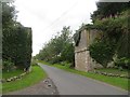
Image Listing (78 Images Found)
Images are licensed for reuse under creativecommons.org/licenses/by-sa/2.0
Image
Details
Distance
1
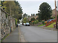
Roxburgh village
The quiet village of Roxburgh, situated on the west bank of the Teviot south of Kelso. At one time it had a railway station at the junction of the branch line to Jedburgh and the E-W line from Tweedmouth to Newtown St Boswells.
Image: © Jim Barton
Taken: 27 Apr 2022
0.01 miles
2
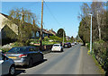
Roxburgh Village
A springtime view of this lovely little Border village on the Teviot.
Image: © Mary and Angus Hogg
Taken: 8 Apr 2017
0.02 miles
4
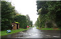
Bus shelter on road junction, Roxburgh
Remains of a railway bridge behind.
Image: © JThomas
Taken: 12 Oct 2021
0.08 miles
5
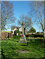
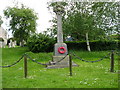
Roxburgh War Memorial
The church in the background lies in the next square.
Image: © Mary and Angus Hogg
Taken: 8 Apr 2017
0.08 miles
6

Roxburgh war memorial
The village war memorial with the parish church behind.
Image: © Gordon Hatton
Taken: 4 Apr 2016
0.08 miles
7
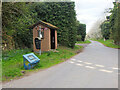
Bus shelter and remains of railway bridges, Roxburgh
The bus stop is at the west end of the village, on the minor road to Nisbet. Covered in vegetation just past the stop are two bridge abutments for the former railways to Kelso and Jedburgh. Roxburgh station was at the junction, out of shot to the right.
Image: © Jim Barton
Taken: 27 Apr 2022
0.08 miles
8
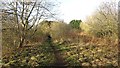
Approaching Roxburgh Junction
The railway from Kelso met a branch to Jedburgh here. The Jed branch failed to recover from catastrophic flooding in 1948 but the trackbed is accessible as far as Nesbit.
Image: © Richard Webb
Taken: 12 Jan 2012
0.09 miles
9
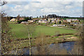
Roxburgh from the viaduct
The village of Roxburgh viewed from the east end of Roxburgh Viaduct with the River Teviot in the foreground. The village is bisected by a grid line.
Image: © Walter Baxter
Taken: 19 Apr 2008
0.10 miles
10
Viaduct, Roxburgh
The railway to Jedburgh crossed a road here soon after leaving the Kelso Branch at Roxburgh Junction.
Image: © Richard Webb
Taken: 21 Aug 2013
0.10 miles