IMAGES TAKEN NEAR TO
Shrewsbury Road, SHREWSBURY, SY5 7DD
Introduction
This page details the photographs taken nearby to Shrewsbury Road, SY5 7DD by members of the Geograph project.
The Geograph project started in 2005 with the aim of publishing, organising and preserving representative images for every square kilometre of Great Britain, Ireland and the Isle of Man.

There are currently over 7.5m images from over14,400 individuals and you can help contribute to the project by visiting https://www.geograph.org.uk
Image Map
Images are licensed for reuse under creativecommons.org/licenses/by-sa/2.0
Notes
- Clicking on the map will re-center to the selected point.
- The higher the marker number, the further away the image location is from the centre of the postcode.
Image Listing (10 Images Found)
Images are licensed for reuse under creativecommons.org/licenses/by-sa/2.0
Image
Details
Distance
1
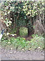
The Cantlop milestone
General view of the milestone set in the hedgerow at Cantlop, on the Shrewsbury - Acton Burnell road, which was turnpiked in 1797. The lettering has weathered, but in close-up you can still read the name 'Salop' (ie Shrewsbury) at the top, and the mileage beneath it of 5.
Image: © Richard Law
Taken: 7 Nov 2015
0.08 miles
2
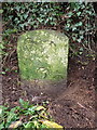
Detail of the Cantlop milestone
This close-up view shows what remains of the fading lettering and mileage roundel, along with the OS benchmark that was levelled at 93.888m above Ordnance Datum Newlyn.
Image: © Richard Law
Taken: 7 Nov 2015
0.08 miles
3
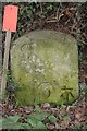
Old Milestone in Cantlop
Carved stone post by the UC road, in parish of Berrington (Shrewsbury and Atcham District), Cantlop; 40m South of Milestone Cottage, by the West side of road. Erected by the Watling Street turnpike trust in the 19th century.
Inscription reads:-
From
Salop
5
Miles
Carved benchmark lower right.
Grade II listed.
List Entry Number: 1055549 https://historicengland.org.uk/listing/the-list/list-entry/1055549
Milestone Society National ID: SA_SBAB05
Image: © A Reade/J Higgins
Taken: 2 Jun 2008
0.08 miles
4
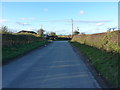
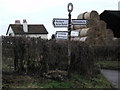
Cantlop Cross
A rural crossroads near the village of Cantlop.
Image: © Richard Law
Taken: 7 Nov 2015
0.11 miles
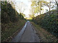
7
Start of byway from Cantlop to Cantlop Mill
Start of byway from Cantlop to Cantlop Mill, nice iron gate to field entrance on the right
Image: © Rob Bainbridge
Taken: 6 Jan 2023
0.18 miles
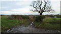
8

Byway to Berrington, so far so good...
A small stream to navigate at this point - it had been raining most of the day (and still was at the time of the photo).
Image: © TCExplorer
Taken: 31 Mar 2023
0.24 miles
9
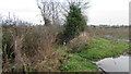
Byway from Cantlop to Cantlop Mill
Entrance to chocked byway from Cantlop to Cantlop Mill, footpath now follows field edge to the right
Image: © Rob Bainbridge
Taken: 6 Jan 2023
0.25 miles
10
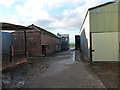
Old and new at Cantlop Farm
By 'new', I'm referring to the barn on the right, which was built in the early 1980s by a local contractor. It's still new by comparison with the one on the left. There is a listed granary in this farmyard, but the same status is not afforded to this particular barn.
Image: © Richard Law
Taken: 7 Nov 2015
0.25 miles