IMAGES TAKEN NEAR TO
Dol-y-Bont, BORTH, SY24 5LX
Introduction
This page details the photographs taken nearby to SY24 5LX by members of the Geograph project.
The Geograph project started in 2005 with the aim of publishing, organising and preserving representative images for every square kilometre of Great Britain, Ireland and the Isle of Man.

There are currently over 7.5m images from over14,400 individuals and you can help contribute to the project by visiting https://www.geograph.org.uk
Image Map
Images are licensed for reuse under creativecommons.org/licenses/by-sa/2.0
Notes
- Clicking on the map will re-center to the selected point.
- The higher the marker number, the further away the image location is from the centre of the postcode.
Image Listing (14 Images Found)
Images are licensed for reuse under creativecommons.org/licenses/by-sa/2.0
Image
Details
Distance
1
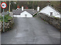
The bridge, D?l-y-bont
A very hump-backed bridge, a source of problems to those with low-slung cars, although careful laying of the tarmac has improved things in recent years.
Image: © Nigel Brown
Taken: 18 Dec 2008
0.01 miles
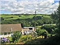
2
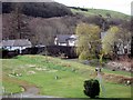
Looking back to Dol-y-Bont
The view from the path that climbs above the caravan park (whose land occupies the foreground). The bridge over the Leri is seen at its best from here.
Image: © Chris Denny
Taken: 2 Apr 2010
0.02 miles
3
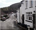
Dol-y-Bont village
Looking down the main street to the bridge over the Afon Leri.
Image: © Chris Denny
Taken: 2 Apr 2010
0.03 miles
4
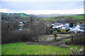
D?l-y-Bont from the B4353
Dôl-y-Bont sits in the bottom of the Leri valley, while the B4353 runs along the valley edge.
Image: © Bill Boaden
Taken: 26 Feb 2011
0.03 miles
5
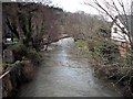
Downstream from the bridge, Dol-y-Bont
The Afon Leri, swollen after recent heavy rains, swirls rapidly past gardens and meadows.
Image: © Chris Denny
Taken: 2 Apr 2010
0.06 miles
6
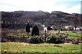
Ornamental lake, Dol-y-Bont
An attractive and quite unusual water feature, topped with a dovecote and a Manx flag, as seen from the public footpath that climbs above the caravan park.
Image: © Chris Denny
Taken: 2 Apr 2010
0.07 miles
7
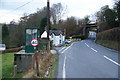
Bus stop above D?l-y-Bont
Dôl-y-Bont is down the road to the left. The villagers have to walk up the hill if they want to catch the bus. The road ahead leads to Llandre and eventually Aberystwyth.
Image: © Bill Boaden
Taken: 26 Feb 2011
0.10 miles
8
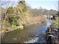
View from the bridge, Dol y Bont
The Leri looking upstream.
Image: © Chris Denny
Taken: 17 Feb 2003
0.11 miles
9
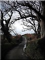
The lane to Brynllys
The narrow lane leading to Brynllys and becoming a track at Pant-y-dwn is framed by trees as it climbs out of Dol-y-Bont.
Image: © Chris Denny
Taken: 2 Apr 2010
0.14 miles
10
From a Machynlleth-Aberystwyth train, house near Pen-y-bont
Image: © Nigel Thompson
Taken: 6 Aug 2016
0.20 miles