IMAGES TAKEN NEAR TO
Phipps Bridge Road, LONDON, SW19 2ST
Introduction
This page details the photographs taken nearby to Phipps Bridge Road, SW19 2ST by members of the Geograph project.
The Geograph project started in 2005 with the aim of publishing, organising and preserving representative images for every square kilometre of Great Britain, Ireland and the Isle of Man.

There are currently over 7.5m images from over14,400 individuals and you can help contribute to the project by visiting https://www.geograph.org.uk
Image Map
Images are licensed for reuse under creativecommons.org/licenses/by-sa/2.0
Notes
- Clicking on the map will re-center to the selected point.
- The higher the marker number, the further away the image location is from the centre of the postcode.
Image Listing (78 Images Found)
Images are licensed for reuse under creativecommons.org/licenses/by-sa/2.0
Image
Details
Distance
1
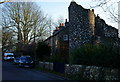
Cottages on Phipp's Bridge Road, Merton
I love the folly, tacked onto the end of the terrace. The River Wandle lies, just out of picture, to the right.
Image: © Peter Trimming
Taken: 25 Feb 2012
0.02 miles
2
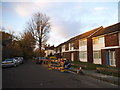
Phipps Bridge Road, Merton
This used to continue to Liberty Avenue but has now been pedestrianised at the end. It is far too narrow for traffic past this point so possibly a good idea.
Image: © David Howard
Taken: 1 Dec 2013
0.02 miles
3
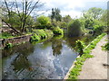
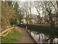
River Wandle near Deen City Farm
After its complicated pattern of courses within Morden Hall Park, the River Wandle passes out of the park under Tramlink as two channels, forming a long thin island. The two channels join up just ahead here, near the entrance to Deen City Farm.
Image: © Marathon
Taken: 11 Apr 2012
0.03 miles
4
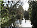
River Wandle near Merton
A view of the River Wandle near Merton, looking south.
Image: © Malc McDonald
Taken: 4 Jan 2020
0.03 miles
5
Wandle at Merton
Close to the view in Image The houses are on Phipps Bridge Road.
Image: © Derek Harper
Taken: 3 Feb 2011
0.03 miles
6
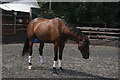
View of a horse in Deen City Farm
Looking south-southeast.
Image: © Robert Lamb
Taken: 4 Aug 2018
0.04 miles
7
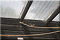
View of zebra finches in Deen City Farm
Looking south-southeast.
Image: © Robert Lamb
Taken: 4 Aug 2018
0.05 miles
8
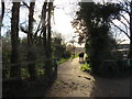
Wandle Trail near Merton
This path forms part of the Wandle Trail. The small blue sign on the fencepost indicates that it is also part of National Cycle Network route 20.
This image was taken on a sunny day in early January. The trees were bare, the sun was low in the sky and shadows were long.
Image: © Malc McDonald
Taken: 4 Jan 2020
0.05 miles
9
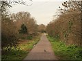
Path beside Deen City Farm
Pigeons take over the path between the Wandle (left) and the city farm, which is off to the right.
Image: © Derek Harper
Taken: 3 Feb 2011
0.05 miles
10
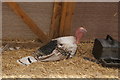
View of a turkey in Deen City Farm
Looking north-northwest.
Image: © Robert Lamb
Taken: 4 Aug 2018
0.05 miles