1
Mortlake: View east from footbridge
Looking in the Up direction, the other footbridge can be seen; behind it and on the right is the Mortlake Old Burial Ground.
Image: © Dr Neil Clifton
Taken: 24 Apr 2013
0.05 miles
2
Mortlake
The railway lines to the east of the station.
Image: © Peter Trimming
Taken: 23 Sep 2017
0.06 miles
3
Looking from North Worple Way into Worple Street
Image: © Basher Eyre
Taken: 31 May 2017
0.06 miles
4
Footbridge connecting North and South Worple Ways
Approaching Mortlake station from the east, the railway is flanked by two narrow streets running parallel to it. South Worple Way is built up only on its south side, North Worple Way only on its north side.
In order to get a view over the high wall, I held the camera above my head, at full stretch.
Image: © Stefan Czapski
Taken: 14 Oct 2011
0.06 miles
5
Tiled panel (1), former "Queen's Arms", Mortlake
The old 'Queen's Arms' - now a private dwelling - stands at the corner of Queen's Road and Prince's Road, Mortlake. Much of the external tiling of the old Charrington's pub has been retained - in a neighbourhood of former artisans' cottages. The date 1757 commemorates the founding of the Anchor Brewery in the Mile End Road - a business which John Charrington bought into a few years later http://en.wikipedia.org/wiki/Charrington_Brewery
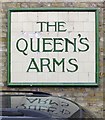
The anchor panel faces Prince's Road. The pub's name survives on a tiled panel round the corner in Queen's Road http://www.geograph.org.uk/photo/2964839
Image: © Stefan Czapski
Taken: 19 May 2012
0.06 miles
6
Queen's Road, Mortlake
Looking south from the footbridge across the railway: http://www.geograph.org.uk/photo/2652146
Image: © Stefan Czapski
Taken: 13 Apr 2014
0.06 miles
7
Mortlake: Former 'Queen's Arms'
Not a pub now and it has probably been converted to houses for some time, but the original signage has, sensibly, been kept and is well maintained. Charrington's Brewery in the City was taken over by Whitbread in the early fifties, but they maintained the 'Charrington's IPA' name for some years.
Image: © Dr Neil Clifton
Taken: 24 Apr 2013
0.07 miles
8
Tiled panel (2), the former "Queen's Arms", Mortlake
The old 'Queen's Arms' - now a private dwelling - stands at the corner of Queen's Road and Prince's Road, Mortlake. Much of the external tiling of the old Charrington's pub has been retained - in a neighbourhood of former artisans' cottages. The pub name appears in this panel on an east-facing wall in Queen's Road.
Another panel, just round the corner in Prince's Road, is shown here: http://www.geograph.org.uk/photo/2964831
Image: © Stefan Czapski
Taken: 19 May 2012
0.07 miles
9
Looking from North Worple Way into Ripley Gardens
Image: © Basher Eyre
Taken: 31 May 2017
0.07 miles
10
No.46100 'Royal Scot'
Seen approaching Mortlake with a circular railtour from Victoria via Woking, Guildford and Redhill.
Image: © Peter Trimming
Taken: 23 Sep 2017
0.07 miles


