IMAGES TAKEN NEAR TO
Berry Hill Road, STOKE-ON-TRENT, ST4 2PQ
Introduction
This page details the photographs taken nearby to Berry Hill Road, ST4 2PQ by members of the Geograph project.
The Geograph project started in 2005 with the aim of publishing, organising and preserving representative images for every square kilometre of Great Britain, Ireland and the Isle of Man.

There are currently over 7.5m images from over14,400 individuals and you can help contribute to the project by visiting https://www.geograph.org.uk
Image Map
Images are licensed for reuse under creativecommons.org/licenses/by-sa/2.0
Notes
- Clicking on the map will re-center to the selected point.
- The higher the marker number, the further away the image location is from the centre of the postcode.
Image Listing (38 Images Found)
Images are licensed for reuse under creativecommons.org/licenses/by-sa/2.0
Image
Details
Distance
1
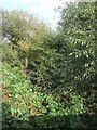
River Trent upstream of A50
Somewhere largely hidden by the dense vegetation the river flows south through Stoke-on-Trent unseen by the citizens. The only clue for its presence are the brick parapets of the bridges.
Image: © John M
Taken: 20 Sep 2009
0.07 miles
2
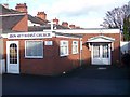
Zion Methodist Church
Situated on Cotesheath Street, Joiner's Square, Stoke-on-Trent. ST1 3JD
Off Victoria Road (A50) which 200mtrs further north meets at roundabout for Leek Road (A52) and Lichfield Street (A50).
Image: © Carl Farnell
Taken: 15 Nov 2009
0.09 miles
3
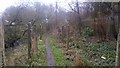
Path along the side of the river trent
Image: © Moston-Harratt
Taken: 24 Nov 2012
0.10 miles
5
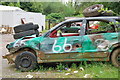
Scrapyard, Venn Place, Hanley
This area is closed off to the public with a barrier, and is right next to a nature park (hidden by trees).
Image: © Stu JP
Taken: 16 Aug 2015
0.13 miles
6
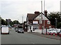
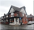
Victoria Road passes Milly's Food Bar
Image: © Steve Daniels
Taken: 18 Sep 2017
0.13 miles
7
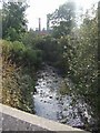
River Trent - Downstream of the A50
The river has become much larger and perhaps cleaner as more tributaries have joined between here and Finney Gardens. Heading south it now passes through Stoke.
Image: © John M
Taken: 20 Sep 2009
0.14 miles
8
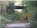
Disused railway bridge
The road originally led to the regional headquarters of British Coal Opencast at Berry Hill.
Image: © John M
Taken: 20 Sep 2009
0.14 miles
9
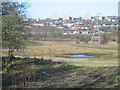
Berry Hill, Stoke on Trent
Looking from the edge of the Berry Hill housing estate across open land that was once part of the Berry Hill colliery. In the background can be seen Hanley one of The Potteries six towns.
Image: © Phil Eptlett
Taken: 9 Feb 2006
0.15 miles
10
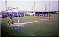
Eastwood Hanley vs Accrington Stanley
Accrington Stanley have progressed through the leagues and rejoined the football league many years after they folded. Eastwood Hanley went the other way and folded in 1997. I gather attempts have been made to resurrect the club - all the best for the future.
Image: © Peter Moore
Taken: Unknown
0.16 miles