IMAGES TAKEN NEAR TO
Richmond Avenue, SOUTHEND-ON-SEA, SS3 9LE
Introduction
This page details the photographs taken nearby to Richmond Avenue, SS3 9LE by members of the Geograph project.
The Geograph project started in 2005 with the aim of publishing, organising and preserving representative images for every square kilometre of Great Britain, Ireland and the Isle of Man.

There are currently over 7.5m images from over14,400 individuals and you can help contribute to the project by visiting https://www.geograph.org.uk
Image Map
Images are licensed for reuse under creativecommons.org/licenses/by-sa/2.0
Notes
- Clicking on the map will re-center to the selected point.
- The higher the marker number, the further away the image location is from the centre of the postcode.
Image Listing (32 Images Found)
Images are licensed for reuse under creativecommons.org/licenses/by-sa/2.0
Image
Details
Distance
1
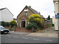
Shoeburyness: Shoebury Evangelical Church
There is a fine display of flowering broom outside this church which is in West Road in Cambridge Town.
Image: © Nigel Cox
Taken: 3 Aug 2008
0.02 miles
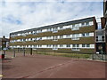
3
Flats in West Road, Shoeburyness
Taken on the corner of Chelmer Way. The latter road (more or less) occupies the site of the former Grove Road which was a street of C19 terraced houses similar to those still standing in nearby Trafalgar Road Image and Waterloo Road.
Image: © David Kemp
Taken: 22 Feb 2018
0.05 miles
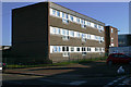
6
Flats in Avon Way, Shoeburyness
Avon Way stands (more or less) on the site of Cambridge Road, a street of C19 terraced houses similar to those in Trafalgar Road Image nearby.
Image: © David Kemp
Taken: 22 Feb 2018
0.07 miles
7
Shoeburyness: Waterloo Road
Waterloo Road is in Cambridge Town. Nowadays Cambridge Town merges into the built-up area of Thorpe Bay and the rest of the conurbation of Southend-on-Sea, but looking at old Ordnance Survey maps of the Victorian period the isolation of the settlement and its role in providing accommodation to civilian workers for the military garrison at Shoeburyness is quite evident. Waterloo Road does not appear in the Ordnance Survey map of 1898 although the next street to the south, once Grove Road, but now Chelmer Road, is shown.
Image: © Nigel Cox
Taken: 3 Aug 2008
0.08 miles
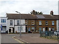
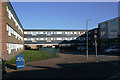
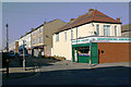
8
West Road, Shoeburyness
Not so long ago West Road was a thriving shopping street. But with the closure of the Shoebury Garrison in 1976 and the opening the Asda superstore ten minutes' walk away five years later, West Road went into decline. Many of the former retail premises are now occupied by charity shops, fast food outlets or closed altogether. The optimistically and inaccurately named Seaview Road can be seen on the right.
Image: © David Kemp
Taken: 22 Feb 2018
0.10 miles
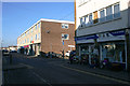
9
West Road, Shoeburyness
Taken from St Andrew's Road. Once a thriving shopping street, West Road has become a shadow of its former self over the years following the closure of the Shoebury Garrison in 1976 and the opening of the nearby Asda superstore in 1981.
Image: © David Kemp
Taken: 22 Feb 2018
0.10 miles
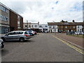
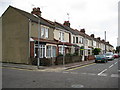
10
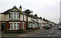
Richmond Avenue, Shoeburyness
Taken at the junction with Caulfield Road. Richmond Avenue marks the western extremity of the C19 parts of Shoeburyness which before 1933 had been administratively separate from neighbouring Southend.
Image: © David Kemp
Taken: 16 Apr 2019
0.10 miles