IMAGES TAKEN NEAR TO
Coronation Road, SALISBURY, SP2 9DD
Introduction
This page details the photographs taken nearby to Coronation Road, SP2 9DD by members of the Geograph project.
The Geograph project started in 2005 with the aim of publishing, organising and preserving representative images for every square kilometre of Great Britain, Ireland and the Isle of Man.

There are currently over 7.5m images from over14,400 individuals and you can help contribute to the project by visiting https://www.geograph.org.uk
Image Map (Loading...)


Getting Data...Please wait
Leaflet Map data © OpenStreetMap
Images are licensed for reuse under creativecommons.org/licenses/by-sa/2.0
Notes
- Clicking on the map will re-center to the selected point.
- The higher the marker number, the further away the image location is from the centre of the postcode.
Image Listing (53 Images Found)
Images are licensed for reuse under creativecommons.org/licenses/by-sa/2.0
Image
Details
Distance
1
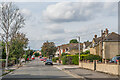
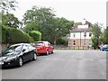
Coronation Road
Road between Roman Road and Queen Alexandra Road. The road was first marked on the 1925 25 inch map, including some of the houses seen here. With neighbouring roads on that map of a King Edward Road (not actually developed, the line now being just a nameless track), Queen Alexandra Road and Empire Road, it would seem that the coronation the road name refers to was that of Edward VII in 1902; the 1925 map was the first survey after that date so there is none earlier to confirm or contradict this suggestion.
Image: © Ian Capper
Taken: 22 Sep 2022
0.07 miles
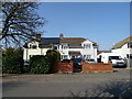
2

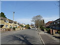
Ladysmith Road
Image: © Jonathan Kington
Taken: 9 Jan 2012
0.11 miles
4
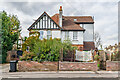
47 Roman Road
House on Roman Road and Queen Alexandra Road first marked on the 1925 25 inch map - from its appearance, it would seem to be Edwardian.
Image: © Ian Capper
Taken: 22 Sep 2022
0.11 miles
5
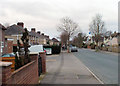
Down Roman Road
Looking down Roman Road towards its junction with Wilton Road at Skew Bridge, the Image is just visible on the left.
Image: © Jonathan Kington
Taken: 9 Jan 2012
0.12 miles
8
Roman Road
Passing the Devizes Road Cemetery.
Image: © Richard Webb
Taken: 31 Aug 2022
0.13 miles
9

Sign for Ladysmith Road
The sign for Image looks a little worse for wear.
Image: © Jonathan Kington
Taken: 9 Jan 2012
0.14 miles
10
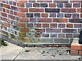
Benchmark on St John HQ
The cut mark can be found on the Image on Roman Road, for more information on this and other nearby benchmarks visit http://www.bench-marks.org.uk/bm40889 .
Image: © Jonathan Kington
Taken: 9 Jan 2012
0.14 miles