
IMAGES TAKEN NEAR TO
Twiss Square, WINCHESTER, SO23 7FF
Introduction
This page details the photographs taken nearby to Twiss Square, SO23 7FF by members of the Geograph project.
The Geograph project started in 2005 with the aim of publishing, organising and preserving representative images for every square kilometre of Great Britain, Ireland and the Isle of Man.

There are currently over 7.5m images from over14,400 individuals and you can help contribute to the project by visiting https://www.geograph.org.uk
Image Map
Images are licensed for reuse under creativecommons.org/licenses/by-sa/2.0
Notes
- Clicking on the map will re-center to the selected point.
- The higher the marker number, the further away the image location is from the centre of the postcode.
Image Listing (28 Images Found)
Images are licensed for reuse under creativecommons.org/licenses/by-sa/2.0
Image
Details
Distance
2
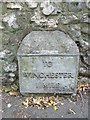
Old Milestone by the A33, Worthy Road, Winchester
Metal plate attached to stone post by the A33, in parish of Winchester (Winchester District), Worthy Road, 100m North of junction with Park Road, partially inset into flint wall, on East side of road. Erected by the Popham Lane to Winchester turnpike trust in the 19th century.
Inscription reads:-
TO
WINCHESTER
1 MILE
Milestone Society National ID: HA_WIBA01
Image: © M Faherty
Taken: 10 Aug 2013
0.08 miles

5
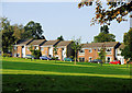
Charles Close, Abbotts Barton
View across the recreation ground.
Image: © Pierre Terre
Taken: 13 Sep 2008
0.13 miles
6
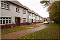
Detached houses in Abbots Walk development
These houses are on the southern side of the development, separated from the pre-existing Francis Gardens by the greenery seen along the right edge of this photo. In the foreground the Buttercross 5-bedroom house, and beyond three Walmesley 4-bedroom houses. They have private gardens behind. They are not on any street, but accessed via the gravel-like path shown which I think is named Monks Walk.
Image: © Peter Facey
Taken: 3 Nov 2013
0.13 miles
7
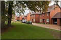
Francis Way
This line of houses is immediately on the right as you enter Cassandra Road. It lies parallel to Worthy Road but is separated from it by a wall and the greenery seen on the left of this photo.
Image: © Peter Facey
Taken: 3 Nov 2013
0.15 miles
8
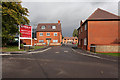
Northanger Drive
An alternative access to the Abbots Walk housing development from the pre-existing Francis Gardens whose road is seen in the foreground. The Bayfield 4-bedroomed house is seen ahead left, whilst that in right foreground is The Buttercross 5-bedroomed detached house.
Image: © Peter Facey
Taken: 3 Nov 2013
0.15 miles
9

Cassandra Road
Looking across the B3047 Worthy Road at the main entrance to this new housing development.
Image: © Peter Facey
Taken: 3 Nov 2013
0.15 miles
10
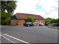
Abbots Barton, The Barn Store
On Chaundler Road; a reminder of the area's agricultutal heritage.
Image: © Mike Faherty
Taken: 11 Aug 2013
0.16 miles