IMAGES TAKEN NEAR TO
Mulgrave Road, SUTTON, SM2 6LP
Introduction
This page details the photographs taken nearby to Mulgrave Road, SM2 6LP by members of the Geograph project.
The Geograph project started in 2005 with the aim of publishing, organising and preserving representative images for every square kilometre of Great Britain, Ireland and the Isle of Man.

There are currently over 7.5m images from over14,400 individuals and you can help contribute to the project by visiting https://www.geograph.org.uk
Image Map
Images are licensed for reuse under creativecommons.org/licenses/by-sa/2.0
Notes
- Clicking on the map will re-center to the selected point.
- The higher the marker number, the further away the image location is from the centre of the postcode.
Image Listing (22 Images Found)
Images are licensed for reuse under creativecommons.org/licenses/by-sa/2.0
Image
Details
Distance
1
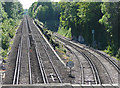
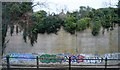
Sutton-Cheam railway (2)
The straight line leads to Cheam, the sinuous one to West Sutton on the Thameslink route. I know next to nothing about such matters, but the latter looks to me to be unusually steep for a railway. Could it explain some of Thameslink's delays? I'm certainly surprised they've never tried that one on.
Taken from the aptly-named Bridge Road, looking in the opposite direction to this photo: Image
Image: © Stephen Richards
Taken: Unknown
0.06 miles
2
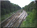
Rail Junction west of Sutton Station.
Taken from Bridge Road. The tracks curving off to the right are the Thameslink via Wimbledon to Streatham and points north, straight on goes to Epsom.
Image: © Noel Foster
Taken: 20 Aug 2005
0.07 miles
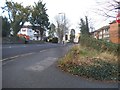
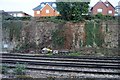
3
Concrete wall by railway line, west of Sutton
Image: © N Chadwick
Taken: 4 Feb 2018
0.08 miles
4
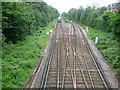
Looking west from Bridge Road, Sutton
This is just west of Sutton station and is seen from Bridge Road. The left hand pair of lines lead to Cheam and were opened in 1847. The right hand lines belong to the Wimbledon to Sutton line. This was first proposed in the early 1880s with the intention of stimulating house building across the clay pastures between the two towns, which up until then had remained largely untouched. It can be seen going into a steep-sided, narrow cutting. As the area was fully built-up by the time of the line's construction, the chalk cutting had to be lined in places with concrete to reinforce its steep sides and so minimise the land take.
The Wimbledon to Sutton line was designed for electric trains, with many inclines and sharp curves, although it hardly justified the drivers' nickname for it: "Wall of Death".
Image: © Marathon
Taken: 27 Jun 2012
0.09 miles
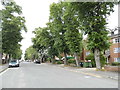
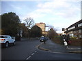
8
Grange Road at the junction of Worcester Road
Image: © David Howard
Taken: 4 Apr 2018
0.18 miles