IMAGES TAKEN NEAR TO
Fairacre, MAIDENHEAD, SL6 4AN
Introduction
This page details the photographs taken nearby to Fairacre, SL6 4AN by members of the Geograph project.
The Geograph project started in 2005 with the aim of publishing, organising and preserving representative images for every square kilometre of Great Britain, Ireland and the Isle of Man.

There are currently over 7.5m images from over14,400 individuals and you can help contribute to the project by visiting https://www.geograph.org.uk
Image Map
Images are licensed for reuse under creativecommons.org/licenses/by-sa/2.0
Notes
- Clicking on the map will re-center to the selected point.
- The higher the marker number, the further away the image location is from the centre of the postcode.
Image Listing (52 Images Found)
Images are licensed for reuse under creativecommons.org/licenses/by-sa/2.0
Image
Details
Distance
1
Rutland Road and Rutland Place, Maidenhead
Rutland Place is the road going off to the left. This is part of the pleasant residential area to the west of All Saints' church.
Image: © Andrew Smith
Taken: 22 Aug 2009
0.06 miles
2
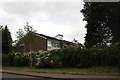
Rear of houses on Boyn Hill Close, Maidenhead
From Bath Road. There is another row of the same houses next to them on the left.
Image: © David Howard
Taken: 8 Jul 2019
0.07 miles
3
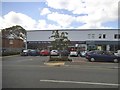
Tesco Express on Bath Road
This was converted from a garage in about 2013
Image: © David Howard
Taken: 9 Aug 2015
0.11 miles
5
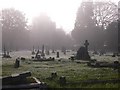
All Saints Graveyard, All Saints Church, Boyne Hill, Maidenhead
The freezing fog does its bit!
All Saints Church: http://www.allsaintsboynehill.org.uk/
Image: © Lee Kindness
Taken: 20 Nov 2005
0.14 miles
6
All Saints, Boyne Hill, Maidenhead, Berks
Image: © John Salmon
Taken: 19 Jul 2008
0.14 miles
7
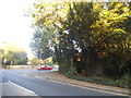
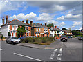
Bath Road at the junction of Boyn Hill Road
Image: © David Howard
Taken: 9 Aug 2015
0.15 miles
8
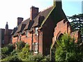
Old Clergy House, Boyn Hill
This forms the western side of the quadrangle of Church Close, of which Image forms the north. "Added by G E Street in 1859 at right angles to and adjoining Parish Centre north side" http://www.imagesofengland.org.uk/Details/Default.aspx?id=40729&mode=adv , which implies that this was originally Boyn Hill Infants School. On the right is the stepped entrance gateway to the close http://www.imagesofengland.org.uk/details/default.aspx?id=40731 .
Image: © Derek Harper
Taken: 9 Sep 2005
0.15 miles
9
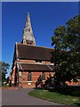
All Saints, Boyn Hill, Maidenhead from Church Close
As originally conceived by G E Street in 1854 and built, the tower was almost freestanding, touching the church at its south-east corner and thus fully displayed to the close of buildings on the south side of the church. The extension of the church by two bays west in 1910-11 by A E Street destroyed that relationship.
Image: © Chris Brown
Taken: 2 Sep 2018
0.16 miles
10
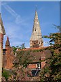
Boyn Hill
The spire of All Saints Church appears over the roofs of Church Close. "The Church ... is part of a tractarian group ..., comprising the former All Saints Vicarage, All Saints School and Schoolmaster's House, All Saints Almshouses and Vicarage Lodge" http://www.imagesofengland.org.uk/Details/Default.aspx?id=40726&mode=adv . The original architect of the 1850s church (also seen in Image) was G E Street. In front is the rear of Vicarage Cottage, contemporaneous http://www.imagesofengland.org.uk/Details/Default.aspx?id=40722&mode=adv . Seen from Boyn Hill Avenue.
Image: © Derek Harper
Taken: 9 Sep 2005
0.16 miles