IMAGES TAKEN NEAR TO
The Poynings, IVER, SL0 9DT
Introduction
This page details the photographs taken nearby to The Poynings, SL0 9DT by members of the Geograph project.
The Geograph project started in 2005 with the aim of publishing, organising and preserving representative images for every square kilometre of Great Britain, Ireland and the Isle of Man.

There are currently over 7.5m images from over14,400 individuals and you can help contribute to the project by visiting https://www.geograph.org.uk
Image Map
Images are licensed for reuse under creativecommons.org/licenses/by-sa/2.0
Notes
- Clicking on the map will re-center to the selected point.
- The higher the marker number, the further away the image location is from the centre of the postcode.
Image Listing (14 Images Found)
Images are licensed for reuse under creativecommons.org/licenses/by-sa/2.0
Image
Details
Distance
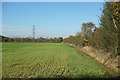
1
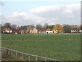
The Poynings, Richings Park, Iver
Looking north in early afternoon over a field of crops from Old Slade Lane, just by the M4 Motorway bridge.
Image: © David Hawgood
Taken: 21 Jan 2006
0.10 miles
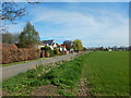
2
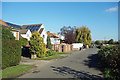
Houses Down One Side
Showing the mixed Town & Country character of this area just beyond the edge of fully built up London.
Suburban housing on one side of the road and farmland on the other.
Image: © Des Blenkinsopp
Taken: 6 Nov 2017
0.12 miles
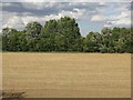
3
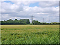
Field of barley
The next field beyond the pylon is also barley.
Image: © Robin Webster
Taken: 10 Jun 2017
0.17 miles
4
Field of Barley
South of Richings Park.
Image: © Robin Webster
Taken: 10 Jun 2017
0.17 miles
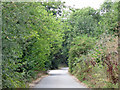
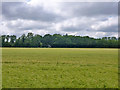
6
Field by the Colne Valley Way
A glance at the map shows that TQ0478 is almost entirely taken up with the M4/M25 interchange. The Colne Valley Way follows a tree lined route alongside one of the slip roads. Continuous noise and not much to see through the trees on either side.
A rare glimpse through the hedge shows that there is still a bit of farming going on in the midst of it all.
Image: © Des Blenkinsopp
Taken: 6 Nov 2017
0.20 miles
7
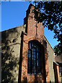
The western elevation of the church at Richings Park
Image: © Shazz
Taken: 4 Sep 2013
0.22 miles
8
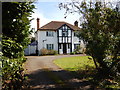
Iver - Old Slade Lane
One of the few original houses left in the street, most of the houses have been completely redeveloped.
Image: © James Emmans
Taken: 25 Mar 2017
0.22 miles