IMAGES TAKEN NEAR TO
Hertford Road, WARE, SG12 9RX
Introduction
This page details the photographs taken nearby to Hertford Road, SG12 9RX by members of the Geograph project.
The Geograph project started in 2005 with the aim of publishing, organising and preserving representative images for every square kilometre of Great Britain, Ireland and the Isle of Man.

There are currently over 7.5m images from over14,400 individuals and you can help contribute to the project by visiting https://www.geograph.org.uk
Image Map
Images are licensed for reuse under creativecommons.org/licenses/by-sa/2.0
Notes
- Clicking on the map will re-center to the selected point.
- The higher the marker number, the further away the image location is from the centre of the postcode.
Image Listing (19 Images Found)
Images are licensed for reuse under creativecommons.org/licenses/by-sa/2.0
Image
Details
Distance
1
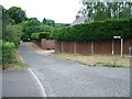
Chardingleye Farm Lane
Seen from its junction with the B1502
Image: © Rob Candlish
Taken: 25 Jul 2010
0.04 miles
3
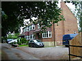
Chardingleye Farm, Great Amwell
Tied cottages on the farm.
Image: © Rob Candlish
Taken: 25 Jul 2010
0.13 miles
5
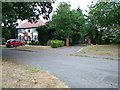
London Road, Great Amwell
Houses at the Amwell Hill end of London Road, now a cul de sac. It was replaced as a through road by the unnamed B1502, which runs beside it and was built in the 1970s at the same time as the dual carriageway A10.
Image: © Rob Candlish
Taken: 25 Jul 2010
0.16 miles
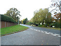
6
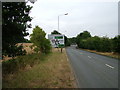
Road sign on the approach to Amwell Roundabout
View from the B1502 looking towards the roundabout.
The eastern boundary of this particular grid square actually passes through the roundabout itself.
Image: © Rob Candlish
Taken: 25 Jul 2010
0.17 miles
7
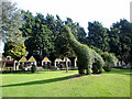
Topiary, Van Hage Garden Centre, Great Amwell, Hertfordshire
Behind the garden centre is this area with large topiary animals and caged birds and animals - a small petting farm.
Image: © Christine Matthews
Taken: 28 Mar 2010
0.19 miles
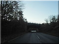
8
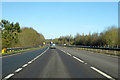
Northbound A10
The slip road from the A414, among others, is tailing off on the left.
Image: © Robin Webster
Taken: 12 Feb 2018
0.20 miles
9
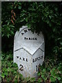
Cast iron mile post in Great Amwell
An old Wadesmill Turnpike Trust cast iron mile post almost lost in vegetation at the junction of Gypsy Lane and Pepper Hill.
Image: © Rob Candlish
Taken: 25 Jul 2010
0.21 miles
10
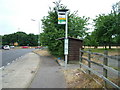
Amwell Roundabout bus stop
An unusual design of bus stop with a large black "hood" over the top of the stop flag. The traffic behind is moving around Amwell Roundabout.
The eastern boundary of this particular grid square passes almost straight along the central reservation and through the roundabout itself.
Image: © Rob Candlish
Taken: 25 Jul 2010
0.21 miles