IMAGES TAKEN NEAR TO
Francis Road, WARE, SG12 9GZ
Introduction
This page details the photographs taken nearby to Francis Road, SG12 9GZ by members of the Geograph project.
The Geograph project started in 2005 with the aim of publishing, organising and preserving representative images for every square kilometre of Great Britain, Ireland and the Isle of Man.

There are currently over 7.5m images from over14,400 individuals and you can help contribute to the project by visiting https://www.geograph.org.uk
Image Map
Images are licensed for reuse under creativecommons.org/licenses/by-sa/2.0
Notes
- Clicking on the map will re-center to the selected point.
- The higher the marker number, the further away the image location is from the centre of the postcode.
Image Listing (122 Images Found)
Images are licensed for reuse under creativecommons.org/licenses/by-sa/2.0
Image
Details
Distance
2
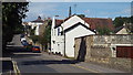
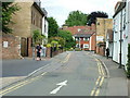
New Road, Ware
New Road seen from its junction with East Street and with Musley Hill rising in the background. The spire on the right belongs to Christ Church.
The sign on the white building on the right is an amusing play on words: it reads "Ware House".
Image: © Rob Candlish
Taken: 25 Jul 2010
0.10 miles
3
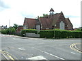
Catholic Church, Ware
The Church of the Sacred Heart of Jesus and St. Joseph, a Roman Catholic church in Ware.
Image: © Malc McDonald
Taken: 3 Aug 2013
0.11 miles
4
The Punch House Ware
Pub just off the high street certainly was popular when i lived here many years ago.
Image: © roger geach
Taken: 18 Mar 2010
0.11 miles
5
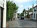
Church Street, Ware
View from just outside Tesco's unloading bay. Articulated lorries with special short trailers have to be used to make deliveries to the Ware branch.
Church Street turns left in front of the building with the white corner stones. Crib Street is to the right there.
The two buildings on the left stand on the site of the area's first purpose built bus garage, which closed in 1934 but survived in other uses for more than sixty years.
Image: © Rob Candlish
Taken: 25 Jul 2010
0.14 miles
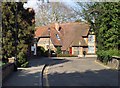
6
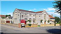
Musley School
The former Musley School seen from the junction of Homefield Road and Musley Hill. Hertfordshire County Council still own the building but seem undecided about what to do with it. Consequently it continues to deteriorate despite its Grade II listed status.
Image: © Rob Candlish
Taken: 11 Aug 2010
0.14 miles
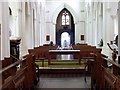
10
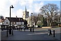
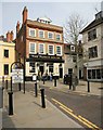
Pedestrianised area off High Street, Ware
St. Mary's Church in distance.
Image: © John Salmon
Taken: 17 Mar 2007
0.15 miles