IMAGES TAKEN NEAR TO
Homefield Road, WARE, SG12 7NE
Introduction
This page details the photographs taken nearby to Homefield Road, SG12 7NE by members of the Geograph project.
The Geograph project started in 2005 with the aim of publishing, organising and preserving representative images for every square kilometre of Great Britain, Ireland and the Isle of Man.

There are currently over 7.5m images from over14,400 individuals and you can help contribute to the project by visiting https://www.geograph.org.uk
Image Map (Loading...)


Getting Data...Please wait
Leaflet Map data © OpenStreetMap
Images are licensed for reuse under creativecommons.org/licenses/by-sa/2.0
Notes
- Clicking on the map will re-center to the selected point.
- The higher the marker number, the further away the image location is from the centre of the postcode.
Image Listing (17 Images Found)
Images are licensed for reuse under creativecommons.org/licenses/by-sa/2.0
Image
Details
Distance
1
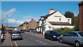
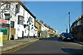
The Crooked Billet, Ware
The Crooked Billet pub in Ware, Hertfordshire.
Image: © Malc McDonald
Taken: 3 Aug 2013
0.09 miles
2
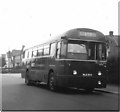
Fanhams Road, Ware
London Country RF604 (NLE604) a 1953 Metro-Cammell bodied AEC Regal IV in Fanhams Road on Hertford and Ware town service route 395A. The junction with Cundalls Road is immediately behind the bus.
The incorrect chalked destination display reading simply "395" seems to indicate that the correct blind could not be found by Hertford Garage. When this photograph was taken route 395A was only operated by single deckers on Sundays, for the rest of the week it was a double deck route.
Image: © Rob Candlish
Taken: Unknown
0.11 miles
3
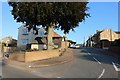
Musley Hill, Ware
Climbing out of the Lea Valley past the Rifle Volunteer pub, near left.
Image: © Robin Webster
Taken: 17 Feb 2019
0.12 miles
4
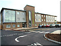
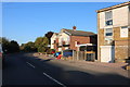
Westgate House Care Centre
Opened in early 2006, it replaces the Old Western House Hospital & Old People's Home which was nearby.
Image: © Melvyn Cousins
Taken: 13 Mar 2006
0.15 miles
5
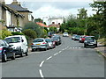
Trinity Road from its junction with Musley Lane
A view along Trinity Road, Ware looking towards Tower Road, the eponymous feature of which figures prominently in the background.
Image: © Rob Candlish
Taken: 11 Aug 2010
0.15 miles
6
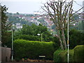
Water Tower in Tower Road
This photo was actually taken with a long lens in Walton Road, Ware at TL359138 and looks over two other grid squares (TL3614 and TL3615). The principal feature is the water tower on the horizon and in grid square TL3615, which gives Tower Road on the other side of the town its name.
The photo also emphasises that the centre of Ware stands at the bottom of the Lea Valley. Modern housing built in the 1950s and 1960s has encroached up the valley sides to both the north and south of the town though.
Image: © Rob Candlish
Taken: 26 Jul 2010
0.16 miles
7
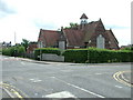
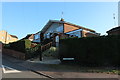
Musley School
The former Musley School seen from the junction of Homefield Road and Musley Hill. Hertfordshire County Council still own the building but seem undecided about what to do with it. Consequently it continues to deteriorate despite its Grade II listed status.
Image: © Rob Candlish
Taken: 11 Aug 2010
0.16 miles