IMAGES TAKEN NEAR TO
Lambscroft Avenue, LONDON, SE9 4PQ
Introduction
This page details the photographs taken nearby to Lambscroft Avenue, SE9 4PQ by members of the Geograph project.
The Geograph project started in 2005 with the aim of publishing, organising and preserving representative images for every square kilometre of Great Britain, Ireland and the Isle of Man.

There are currently over 7.5m images from over14,400 individuals and you can help contribute to the project by visiting https://www.geograph.org.uk
Image Map
Images are licensed for reuse under creativecommons.org/licenses/by-sa/2.0
Notes
- Clicking on the map will re-center to the selected point.
- The higher the marker number, the further away the image location is from the centre of the postcode.
Image Listing (24 Images Found)
Images are licensed for reuse under creativecommons.org/licenses/by-sa/2.0
Image
Details
Distance
1
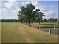
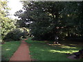
Mottingham Sports Ground
The Green Chain Walk heads down the tarmac path towards Lower Marvel Wood in the distance.
Image: © Marathon
Taken: 16 Jul 2010
0.13 miles
2
Green Chain Walk in Mottingham Sports Ground
The long distance walk heads from Mottingham Wood, right through the ground towards Grove Park Road.
Image: © David Anstiss
Taken: 18 Sep 2011
0.14 miles
3
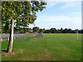
Green Chain Walk crossing Mottingham Sports Ground
There are several branches of the Green Chain Walk south of the A20. This one crosses Mottingham Sports Ground. The road leads from Grove Park Road to a pavilion.
Image: © Marathon
Taken: 15 Sep 2012
0.17 miles
4
Green Chain Walk enters Mottingham Wood
The long distance path heads right into a small wood before heading towards Dunkery Road, from a large sports ground on Court Farm Road.
Image: © David Anstiss
Taken: 18 Sep 2011
0.17 miles
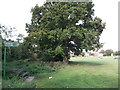
5
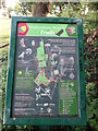
Mottingham Wood Trail Information Board
As seen in Image
Shows the route of the Green Chain Walk (long distance path) through the wood and other details.
Image: © David Anstiss
Taken: 18 Sep 2011
0.18 miles
6
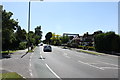
Grove Park Road
Grove Park Road is one of the routes you would take travelling between Eltham and Bromley. Nice big houses on the right and pleasant park (Foxes Field) on the left.
Image: © Martin Kerans
Taken: 30 May 2009
0.18 miles
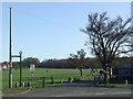
7
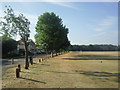
Mottingham Sports Ground and Court Farm Road
Court Farm Road runs along the eastern side of Mottingham Sports Ground. This wide open space leads up to Lower Marvels Wood and is crossed by the Green Chain Walk.
Image: © Marathon
Taken: 3 Aug 2010
0.19 miles
8
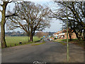
Court Farm Road
No farm now, just suburban housing and playing fields.
Image: © Robin Webster
Taken: 4 Feb 2012
0.19 miles
9
Green Chain Walk in Mottingham Woods
The long distance path leads through the woods from Court Farm Road sports ground towards Dunkery Road.
Image: © David Anstiss
Taken: 18 Sep 2011
0.19 miles
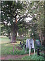
10
Green Chain Walk through Mottingham
The Green Chain Walk is a walking route linking green open spaces across South East London. The signpost to the left of the image points the way here, as it crosses a sports field in Mottingham.
Image: © Malc McDonald
Taken: 19 Mar 2011
0.20 miles